Wednesday, November 16, 2011

Two Recent Hikes


Gold Pond and Little Si (November 9 or 10) or I DON’T EVEN KNOW WHAT DAY IT IS

The day after we walked around Gold Pond it snowed and now it’s beginning to look like it’s going to stay. We’d been keeping track of the weather forecasts and since we knew snow was coming we made a quick run up Little Si (for exercise) then dashed up to Gold Pond a little east of Snoqualmie Pass (accessed from Hyak) to capture one last golden day of sun.

Perhaps it’s just age but it seems like winters last longer than they used to and conversely, summers are shorter. Older folks like us have griped about this since probably the beginning of Time so why should we be different? We know there are fewer summers ahead of us than behind us; hence, our attempts to make the golden days last as long as possible.

We are not fast hikers but we hike at least 3-4 times a week in summer, less often in winter. While we don’t mind hiking through drizzle or rain showers we admit we don’t like hiking in rain or wind (especially rain and wind).

Each year about this time I go to battle with my “demons” – cursing the darkness and longing for light and color. As for “light” there just isn’t enough of it. As if Time wasn’t already going fast enough, must we have our daylight taken away too? Yet, who are we (puny humans!) to argue with the Forces that created all this.

Another thing that bothers us about winter are the “brown” hikes, when all color seems drained out of the landscape, the last fall leaves have turned to mush, the trees are bare, with only the occasional green brilliance of moss or lichen to break up the monotony. With the expense of driving a factor there are only so many places we can get to this time of year and frankly, some of them aren’t worth it (except for the exercise).

Hence we look upon “brown” hikes as medicine, as necessary to keep us running as fuel is to a car. But – we don’t have to like it.

Ahhh - those last golden hikes this fall were poignant; each one felt like the “end”. Yet for a while, each golden hike we thought would be the “last” one – wasn’t. Our hike to Sand Lake felt like the last golden hike; it wasn’t. Also, Kendall Katwalk, Granite Mountain, Talapus and Olallie, Crystal Lakes, even a hike from Cayuse Pass to Sheep Lake – it was an unusually good October.

Little Si and Gold Pond, though, were regrettably the last golden hikes; at least for us on the west side.
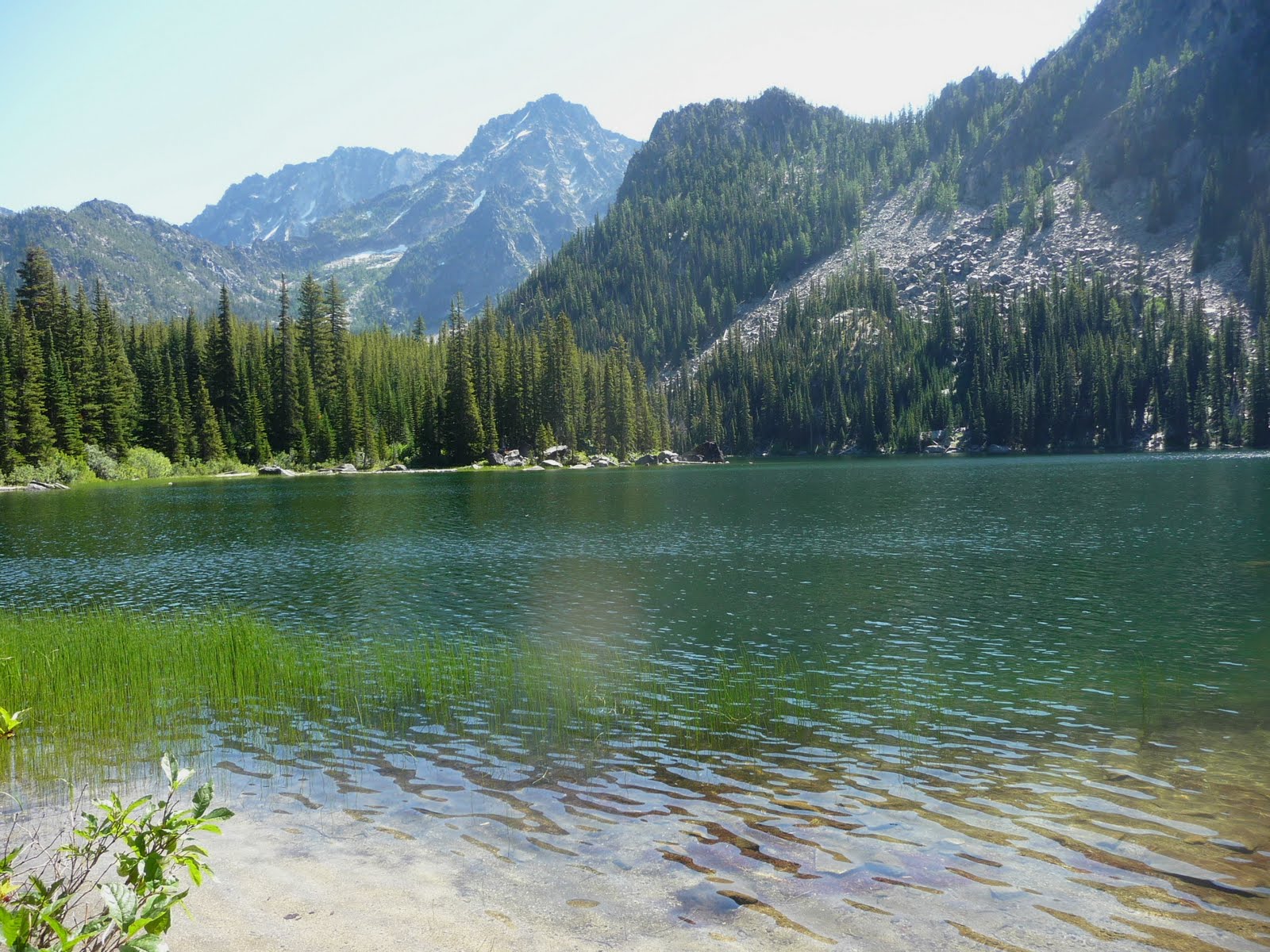
The hike to Little Si was beautiful; the sun was shining, there were still leaves on the deciduous trees though some had fallen. It was a pleasant hike; we enjoyed it but it wasn’t enough of a hike to see us through the dark days to come. Since the sun was bright and it hadn’t taken us long to hike Little Si we drove to Gold Pond, a little east of Snoqualmie Pass (accessed from the Hyak Exit No. 54).

We couldn’t have timed it better. Again, we were blessed with blue skies, sun and quite a bit of fall color. Gold Pond is our “favorite” short hike off I-90 near Snoqualmie Pass. Perhaps calling it a “hike” is a bit of a stretch but because it was such a beautiful day it was enough to make us happy.

Though the boardwalks sparkled with frost and fallen leaves were edged with ice; there was still a little warmth in the sun and the low-angle of the sunlight made for good photography. We savored every colorful leaf, every twinkle of frost. Plus, it was so quiet there - it was almost as if Gold Pond knew winter was coming; we felt like it was waiting, holding its breath, sad like us to let the summer go. Rampart Ridge had a dusting of snow and looked cold as did Chikamin Peak as viewed from Gold Pond. Yes though those views were inspirational they also made us sad. Though our fingers were cold we took our time walking around the pretty pond, stopping for photographs, savoring each moment.

I know we will have some good times this winter; we always do. Somehow, though, that doesn’t seem to make the winter go by any faster and we long for trails that are neither white with snow nor brown with leaves.

Yesterday (November 15) we hiked the Section Line Trail to West Tiger 3 and took the regular trail back down; a brown and white hike. Most of the leaves have fallen from the deciduous trees and are lying on the trail – near the summit snow had already fallen and it was cold enough that we didn’t linger.

Our next hike? To be determined.

Friday, October 21, 2011

Granite Mountain, Alpine Lakes Wilderness, October 2011


GRANITE MOUNTAIN (Alpine Lakes Wilderness)

We have a love/hate relationship with the Granite Mountain Trail. It’s a hard hike for many with significant elevation gain and mileage; the reward for the toil is worth it for hikers who stick to it. Those who have hiked to Granite Mountain and the Granite Mountain lookout on a regular basis get to know each switchback by name (we’ve never counted them) and after several trips over the years we look for the tree that designates the beginning of the Alpine Lakes Wilderness.

Our hike yesterday (10-17) was no exception though the weather was exceptionally good for mid-October. Though it was cool in the shade when we started by the time we were out of the forest and onto the open slopes of Granite Mountain the sun was warm and the fall colors so intense it looked like the mountain was on fire.

The first stretch of the trail – as many trails in the Pacific Northwest – starts out in forest but this is old forest, quiet and deep. When you get to the junction for Pratt Lake/Granite Mountain go straight uphill – you’d turn left if you were heading to Pratt Lake.

Still in the forest the trail continues its intense climb and eventually enters the Alpine Lakes Wilderness (designated by a sign). The foliage thins out a bit and there are a few peeks ahead to blue sky and swatches of fall color.

Views improve every step of the way – this is high country at its finest with views down to I-90 and McClellan Butte resembling a great bird with its wings spread about to soar. The trail continues through the Halloween candy colors of fall – the blueberry shrubs were turning red; some still held bountiful berries. The beargrass that lined the trail earlier in the season has lost it’s white plume of a flower but the ragged, skeletal stalks remain amidst bright pockets of mountain ash, hanging meadows with occasional white snags and then looking very far away – the lookout comes into view.

The climbing relents as the trail approaches two small tarns in a meadow; the fall colors above the tarns were reflected in the water. The tarns are the ideal spot for a break before girding yourself for a still-steep ascent.

From the tarns the trail spurts upward again then winds more gently through large boulders and meadows. The lookout appears again, still looking very far away though it’s closer than it looks.

The trail relents again and is level for a bit before one more steep push through forest to a boulder field; then suddenly you are there. The lookout is closed for the season but there are plenty of places to settle and the views will take what breath remains away.

First we stopped for lunch at the lookout; where it was warm and sunny enough that a chipmunk popped up from the rocks and dashed about hoping for handouts. From there we enjoyed views of Mount Rainier amidst a sea of undulating ridges and Mount Adams further to the south.

Two companions opted to hike the trail back to the tarns; three of us opted for the scramble route on boulders to the tarns where we’d rendezvous. The scramble is not particularly dangerous though good balance and some off-trail hiking experience comes in handy. Later in the year when snow falls, the scramble route over the boulders becomes hazardous as snow fills in crevices between the rocks and it’s all too easy to twist an ankle or worse.

We suggest you hike this trail soon – once significant snow accumulates the trail becomes dangerous in the open areas and avalanches can roar down without warning.
However, with a dusting of snow the hike can still be done and is spectacular then, especially when there is still fall color (watch for ice as temperatures drop).

As always never hike beyond your comfort level and always tell someone where you are hiking and when you are expected to return.

The map is Green Trails No. 207 Snoqualmie Pass.

Sunday, October 16, 2011

Kendall Katwalk, October 15, 2011


KENDALL KATWALK (OCTOBER 15, 2011)

What can I say about the Kendall Katwalk that hasn’t been said before? It’s a fairly long hike (12 miles round trip with about 2,700 feet elevation gain via the PCT at Snoqualmie Pass). The scenery is spectacular from beginning to end.

The first stretch is mostly forested but with occasional flashes of colorful vine maple here and there. Devil’s club has turned yellow, its big leaves reminiscent of maple leaves but with treacherous needle-like stickers. It was no surprise there are few flowers now along the trail – in the forest remnants of Canadian dogwood, aged Solomons seal and vanilla leaf. At the Katwalk there were a few harebells and a bit of yarrow.

We always looked forward to that first view of Guye Peak as the PCT leaves the forest to contour below a boulder field. There are also growing views of Red Mountain and Snoqualmie Mountain (Snoqualmie Mountain was dusted with fresh snow that melted away by afternoon).

Shortly past a slightly tricky stream crossing there’s a junction for the Commonwealth Basin trail (it’s signed). The trail to Commonwealth Basin can be used as a shortcut back to the PCT trailhead but stream crossings in the basin can be dicey, especially after recent rain and some snow-melt. The “old” Commonwealth Basin trail is a stretch of the original PCT before the trail was rerouted – it was called the Cascade Crest Trail then.

Past the junction to Commonwealth Basin the trail climbs through dense vegetation - blueberry shrubs, bracken, fading hellebore and mountain ash. After a while the dense vegetation gives way to old-growth forest and another stream crossing, this one easier than the first though at first glance it looks worse than it is.

The next stretch climbs through old-growth forest and you’ll see where trail crews cleared a large blowdown earlier this year. You’ll begin to see bits of sky through the forest canopy and about the time you think the forest will never end the trail breaks out below Kendall Ridge. In October the views are mesmerizing. Colorful fall foliage extends to the base of the ridge (right) and you will unconsciously slow your pace to take in the colorful displays. There are also views of the Snoqualmie peaks.

I’ve only been on the true summit of Kendall Peak once and that was a few years ago. It was the last Mountaineer scramble that the late Paul Wiseman led for the Seattle Mountaineers. The scramble to the true summit is trickier than it looks (at least I thought it was so) and from the trail it is hard to tell which of the high points is the summit.

The PCT its way around Kendall Ridge and here we found a thin layer of snow and occasional ice in the shade; not enough yet to warrant Yak Trax or traction devices but that can change any day now. There was a definite winter chill in the air despite the sun and blue skies.


If you have time notice the boulders beside the trail – they are splashed with lichen in just about every color you can imagine and in places sparkled with a glaze of ice. After some minor ups and downs the trail reaches a viewpoint – this is not the Kendall Katwalk but the views are impressive.

The PCT continues, making a long curve as it contours above a talus slope then comes to the Kendall Katwalk. Just before you get to the Katwalk the trail is narrow and a sign encourages horseback riders to dismount. It’s no place for a fall. Just before you get to the Katwalk peer through a window in the big boulders that border the trail for an interesting frame and view of Red Mountain, Lundine and more.

The Katwalk is snow-free and was the ideal place to stop on this chilly, sunny day. Here we enjoyed views of the Four Brothers, Chikamin Peak and other peaks we weren’t sure we could properly identify. Since we’ve hiked this trail often we didn’t bring the map – that’s a mistake if you want to identify the surrounding peaks.

Since it was a sunny Saturday there were many other hikers on the trail but who can blame them? Most of the hikers we met were younger and probably work full-time – who can begrudge their desire for a golden hike on a Saturday? I used to be one of those weekend-warriors after all. In my 30s, 40s and 50s I mostly worked full-time positions and hiked, scrambled, snowshoed or skied both days of the weekend.

Bob and I dawdled both coming and going – you can blame that on the somewhat futile attempt to immortalize these splendid scenes with our cameras.

Don’t forget your Northwest Forest Pass as we did in our eagerness to get outside on a sunny day. I didn’t realize it was sitting at home until we were half-way to Snoqualmie Pass. We ended up having to use my debit card to purchase a day-hiking permit at one of the grocery stores at the pass. I don’t remember the name of the store but it’s the first one grocery/gas station you come to as you approach Travelers Rest from the west (Exit 52). You will need a permit to park at the trailhead and parking is not allowed near the freeway interchange. You’re likely to get towed if you attempt to park there. Buck up, admit you’re getting old and forgetful and purchase a pass if you need to (to be completely honest …. I often forgot important items in my 30’s too, like the time I forgot my blue foam sleeping pad on a wintry, snowy backpack but that’s another long story…..).

I guess that’s called being human.

Thursday, October 13, 2011

In Search of Color, Talapus and Olallie Lakes


October 13, 2011

Today the two Bob's and I trudged to Talapus Lake. Trudged? Well ... yes. One Bob is recovering from a cold (as am I) and the other Bob is still getting used to heart medication. Plus, a summer of hard hiking has caught up to me as well as another blankety-blank birthday. I'm getting long in the tooth - how did that happen?

It felt like fall today. A chilly morning and cold in the shadows. No fall color until we reached the trailhead; then a visual shout of fall color right there. That whetted our appetite for more.

For some strange reason I find the trail system to Talapus/Olallie lakes confusing; that's perhaps due to the social trails that weave in and out of the main trail and near the lakes. No matter, we made it to both after one false turn.

We didn't see any more fall color until we reached Talapus Lake; the view of the lake and the surrounding boulder fields was stunning. Perhaps we should have called it a day there - it was a pretty scene but we were greedy and wanted more.

On to Lake Olallie where there was little color but there were wisps of mist rising from the lake as if they were living entities (perhaps they were). Again, we had the lake to ourselves and even in the sun it was chilly. The mountain ash was still green; there was only a smattering of dull orange on talus slopes above the lake. Nothing as vivid as the trailhead!

Most of the hike was/is in the forest with several sections of boardwalks in various ages of repair, none lethally slick. No formidable stream crossings, no wildlife sightings, no other hikers until we were on the way down. There are some handsome old-growth trees here and there, vine maple, Canadian dogwood (sans berries), fading vanilla leaf, bead lily without the bead. The forest looks old and feels old too.

If you hike this trail notice the moss-covered trail sign not far from the trailhead. It's been there for a long time. It may even be older than us.

Karen

Oh yeah - the stats (7 miles with 1,350 feet gain but that includes some lost time and additional gain on the network of social trails near Talapus Lake.)

Wednesday, September 28, 2011

Scottish Lakes High Camp


SCOTTISH LAKES HIGH CAMP (September 22-23, 2011)

You may have second thoughts about a visit to Scottish Lakes High Camp when a rusty, wind-shield cracked vehicle (or snowmobile) meets you at the gated road where the fun begins. Relax, the rollicking ride on this four-mile, rock-studded, pot-holed road is a jolly prelude to good times. Let the romp to the cabins or the Day Lodge be part of the experience. The proprietors, Don and Chris Hanson, wear many different hats and they are veterans of transporting guests up and down the road. When it snows, the aging Suburbans are replaced by Snowmobiles and Sno-cats and having experienced the ride to High Camp in winter we can attest you are in good hands. Don and Chris keep the high camp in top-notch conditions and their loyal care-takers when they are not available are the best. Zeke, the caretaker we met, was as likable as the Hansons and was patient with us when we had trouble getting a fire started in the cabin designated for our stay.

Not only are the Hansons and caretakers able to handle just about any contingency, they are patient with their patrons (I left my sleeping bag on the front porch in Seattle along with a couple other items). I’d like to blame such forgetfulness on anticipation rather than age though I’m probably not the first to leave a sleeping bag nor will I be the last.

Rest assured you won’t freeze to death if you forget your sleeping bag or have trouble lighting the fire (I was able to borrow a sleeping bag). If that’s not enough to attract you to spend at least one night at this remarkable place the Day Lodge is open from 8 a.m. to 8 p.m. Coffee is free though Zeke cautioned that if you want coffee before 8 a.m. it’s $5 a cup. We think he was joking.

The day lodge also provides maps (some created by the Hansons), reading material, games, puzzles and other amenities including a sauna and hot tub where you can relax and ponder the stars in the night sky.

Since it was mid-week we were the only guests (weekends are busy!) and our cabin, Larkspur, was ready for our arrival. After the rollicking ride the Hansons delivered us, with our gear, cooler and food, to the front door of Larkspur Cabin, a delightful A-frame cabin with a front porch and a loft.

Other than bringing your own food (and a sleeping bag!) just about everything else is provided other than hiking gear, skis or snowshoes. There were instructions inside the A-frame as how to light the propane lamps, light the fire in the woodstove and other helpful instructions on how to live off the grid for a while.

We were eager to hit the trails; it was a sunny day and fall color was beginning to show in the mountains. With a Green Trails map (Chiwaukum Creek) and a map of trails created by the Hansens of their trail system leading to McCue Ridge and other points of interest we set out for Chiwaukum Lake (6 miles round-trip) and Larch Lake (10 miles round trip). We started from High Camp and followed the trail system as it climbed through forest and tawny meadows toward McCue Ridge.

With plenty of time at our disposal we stopped to admire the wildflowers; many had faded though the buckwheat was still colorful and the desiccated leaves of balsamroot made for natural dried flower arrangements tethered to the mountain. Where the trail was vague there were cairns to follow as the trail continued to climb.

At an unsigned junction on McCue Ridge we turned left. If Lake Julius is your destination go straight. Just before the trail begins its descent to Chiwaukum Lake there are glimpses of the mile-long lake through the trees, then it disappears again. As the trail loses elevation it skirts hanging meadows just beginning to pick up fall colors, especially the fireweed, a brilliant red. The trail returns to forest and remains there, dropping more steeply until it breaks out at the far end of the lake, elevation 5,250 feet.

Though we didn’t see a trail sign we knew to turn right for Larch Lake. First we walked a short spur that led to a perfect spot for lunch in a clearing with logs to sit on at the edge of the lake. Here dark sedges and billowing green reeds bordered the lake and it was so peaceful there that my companion elected to wait there as I continued to Larch Lake.

To ensure we had plenty of time to hike out so we established a time to rendezvous at Chiwaukum Lake. That gave me an hour to get to/from Larch Lake but since that left no time for photography I opted to spend time in Ewing Basin which is situated between the lakes.

If Larch Lake (or Ewing Basin) is your goal - from Chiwaukum Lake the trail continues two miles to Larch Lake, skirting a large meadow on the way and crossing Chiwaukum Creek (an easy hop, skip and jump). After crossing the creek the trail began to open up as it entered the basin so I slowed my pace accordingly.

Ewing Basin is a about a mile from Chiwaukum Lake, a sublime high-country setting with touches of fall color in a boulder-strewn meadow, blueberry shrubs touched with crimson, ridges stretching above with hanging meadows, some still green, others just turning russet. As if that were not enough to keep a hiker spellbound there were still wildflowers in bloom including Indian Paintbrush, arnica, yarrow and blue gentians, a late-summer flower that heralds the end of summer.

It was so beautiful in Ewing Basin that I felt almost guilty for having the whole basin to myself. I knew I would never be able to find the words to describe such beauty so I focused on photography, hoping that my photographs could compensate for the inadequacy of words.

Muttering to myself about the tyranny of the clock and shorter days, I headed back, always mindful about sticking to a turnaround time when someone is waiting. Larch Lake would have to wait for another day. It was little solace that I’d been to Larch Lake so long ago that digital cameras hadn’t even been invented. What remains of that long-ago visit is a box of slides in the basement and good memories. Chiwaukum Lake is beautiful but plan on getting to Larch Lake if you can for even wilder and scenic views.

Back at Chiwaukum Lake my companion was waiting for me (I was only one minute late!) and we trudged out of Chiwaukum Lake already anticipating the comforts of the cabin. Hikes always take longer going out it seems – fortunately there were scenic spots the entire way back, including the way the late afternoon light brushed the dark ridges and mountains with a copper tinge.

The next morning we took an easy walk to Picnic Point (about two miles round trip from High Camp). The walk is on a gravel road through clear cuts with views of Glacier Peak. The clear cuts provide a feel for the topography; you can see the spine of the mountains rising from the earth and vegetation beginning to fill in the blank spots that were logged. First we stopped at the short spur to Glacier View (well signed) in hopes of getting a view of Glacier Peak but the clouds were too low. Glacier View is about half-way to Picnic Point where the road ends at an old landing with a connection to the McCue Ridge Trail. A picnic table is provided, of course, where you can enjoy a snack or feast on the views.

Additional Information: You can also approach Chiwaukum Lake and Larch Lake from the Chiwaukum Creek trail though that is a much longer approach and best done as a backpack. The map is Green Trails No. 177 (Chiwaukum Mountains). Other hikes easily within reach of High Camp are Lake Julius and Loch Eileen. Call the Wenatchee River Ranger District in Leavenworth for additional rules/regulations at 509-548-6977 or visit their website at www.fs.fed.us/r6/wenatchee

For additional information on lodging, rates and seasonal bests or to make a reservation at Scottish Lakes High Camp call 509-763-3044 or visit the website: http://www.scottishlakes.com . You can also view the site for winter cabin availability (2011-2012), a trail map (including ski trails), and a 5-day weather forecast. Dogs are OK if well-behaved and last but certainly not least, Scottish High Camps is also family friendly.

Karen Sykes

Friday, September 2, 2011

Lake Stuart, Alpine Lakes Wilderness


STUART LAKE (ALPINE LAKES WILDERNESS)

You may find it so hard to choose between Colchuck Lake and Stuart Lake for a day hike that you’ll need to flip a coin. Better yet, spend a weekend in Leavenworth and hike to both (or backpack).

Here are a few considerations to help you decide if you only have time to visit one of these lakes.

The trail to Stuart Lake is longer and less steep than the trail to Colchuck Lake but probably a little less crowded. Many hikers/backpackers opt for Colchuck Lake because that is a popular route into the fabled Enchantments. Writing about the Enchantments is beyond the scope of this description but if you’re interested in camping there you’ll need to make a reservation well-ahead of time.

Another consideration - Colchuck Lake is colder, deeper and the trail has more of a mountainous feel to it than Stuart Lake. Having hiked to both lakes we can attest the lakes do have different personalities. Stuart Lake is mellow and inviting; Colchuck is stunning but can also be forbidding. Both lakes are beautiful, each set within granite basins below the Stuart Mountain range.

Since summer temperatures can soar into the mid-90s we settled on Stuart Lake. Do plan an early start – we found the trailhead parking lot almost full when we arrived. Luckily, we managed to find a spot and were soon on the trail.

The trail begins in forest shady enough that twinflower and bead-lily can be found; in September you will be grateful for that shade as the trail begins to climb. Though the trail is rocky in places overall the trail is in good condition as it parallels Mountaineer Creek and easy to follow. Mountaineer Creek also plays a role in helping you stay cool on a warm day by sending you refreshing breezes along the trail.

Between sheltering pines notice where boulders have come to rest; at some point in geologic time having tumbled from ridges and peaks above. In about 0.7 miles the trail enters the Alpine Lakes Wilderness.

At about 1-3/4 miles you’ll cross Mountaineer Creek on a sturdy footbridge. Shortly after crossing the creek the trail splits (4,509 feet); continue straight for Stuart Lake (left for Colchuck Lake). Shaggy, knee-high meadows begin to alternate with pine forest and there are still plenty of wildflowers in bloom including delphinium, Indian paintbrush, asters, columbine, arnica and cow parsley.

As you hike take in dramatic views of the stark ridges above; none are within easy reach of hikers. There are also views of Argonaut Peak as you head toward the lake (though the peak is smaller it bears such a close resemblance to Mount Stuart that without a map it is easy to confuse them).

In 4-1/2 miles Stuart Lake (5,075 feet) comes into view; here a path follows the north shoreline with inviting campsites and niches for lunch spots. Most of the campsites were occupied; a large day-use area has been posted “no camping”. If you can’t find a niche beside the lakeshore the day-use site has plenty of room for day-hikers with good views of the lake, surrounding peaks – the sandy reed-lined shoreline also provides opportunities for wading. Bring a map to identify the peaks visible from Stuart Lake including Mount Stuart, Sherpa Peak, Argonaut Peak and Colchuck Peak.

You can explore the trail further as it parallels the lakeshore – here and there rock outcroppings perch above the lake for better views of the peaks. A rough fisherman’s path continues, climbing to Horseshoe Lake where there are purportedly better views of Mount Stuart.

To get there: from the west end of Leavenworth turn onto Icicle Creek road, drive 8.4 miles then turn left onto FS Road No. 7601, continue 4 miles on gravel road to the designated trailhead and facilities (3,389 feet elevation). Fill out a day-use wilderness permit provided at the trailhead before setting out and you’ll also need to display a Northwest Forest Pass.

If you’re hungry after the hike stop at The South Restaurant in Leavenworth for Latin-infused cuisine (hot, hot, hot!) and/or cold drinks. The restaurant is on Front Street in Leavenworth, a block off US 2.

Stats: The hike is 10.5 miles round trip with about 1,850 feet of elevation gain (including ups and downs). The maps are Green Trails No. 209 Mount Stuart and Green Trails No. 177 Chiwaukum Mountains.

For additional information, rules, regulations and current conditions contact Okanogan-Wenatchee National Forest (Leavenworth) at 509-548-6977 or visit their website at www.fs.fed.us/r6/wenatchee


Saturday, August 6, 2011

Glacier Lake, Goat Rocks Wilderness

Glacier Lake (Goat Rocks Wilderness)

We’re glad we didn’t read trail reports before we discovered this hike. Last year the road to the trailhead was inaccessible, blow downs and landslides messed up the trail and those doughty souls who made it to Glacier Lake despite those obstacles were so fatigued by the time they got there they were disappointed.

We found the trail on a Green Trails map and since it was close to Packwood, one of our favorite areas to explore, we drove there to check it out. Getting there was easy enough though we did find Road 2110 unsuitable for a passenger vehicle. Instead, we parked along the shoulder of FS Road 21 – the trail is signed.

After a short jaunt on the forest service road we came to two washouts – the road is closed prior to the washouts but there is no room to park. It wasn’t a deal-breaker as the road walk is less than ½ mile and in August the road was bordered with wildflowers.

There is also a sign where the trail begins so it’s hard to miss. There are self-issued permits at the trailhead to enter the Goat Rocks Wilderness so be sure to fill one out. We weren’t sure about the NW Forest Pass so we made sure it was visible on the car.

The trail has several ups and downs, some of them steep. Trekking poles are advised for some of the steep sections. While the steep stretches are not exposed it’s easy to skid on the dirt/pebble surface. Other than that the trail is in good condition though I wouldn’t recommend the hike for children.

Though the trail is short I’d rate this as a strenuous hike as per the GPS the elevation gain is greater than in previous hike descriptions. The trail offers views of old-growth forest at its finest with plenty of vine-maple all along the trail and at the lake. As you approach the lake mossy boulders begin to appear and the trail skirts a jumble of jumbo boulders en route to the lake. You can make your turnaround the boulders if you prefer – there are views of the lake – or continue a short stretch to the lakeshore for better views of the lake.

At one time a trail went around the lake (the lake is huge) but the tread we found appears to show little use so we didn’t pursue it. There is an enormous cedar tree that frames one of the campsites near the shoreline; one of the most impressive we’ve seen.

Solitude is practically a given – we only encountered two other hikers.

On our way home we stopped at Packwood to visit the Packwood Museum (it used to be a school) as it was open. We spent a couple hours there viewing the exhibits and talking to the nice folks that volunteer their time and work to keep it open. We can honestly say this is one of the most interesting museums we’ve ever visited so make it a point to stop by.

Getting there: From Packwood drive 3 miles (west) on US 12 to FS Road No. 21 (signed) then continue to spur 2110 (signed) on the left – the road is okay for passenger cars. The map is Green Trails No. 302 Packwood WA.

The hike is 6.5 miles round trip, approximately 2,100 feet gain with ups and downs.

Tuesday, June 21, 2011

Rock Mountain Trail, Lake Wenatchee


Rock Mountain trail to snowline (June 20, 2011)

While Rock Lake and Rock Mountain are still snowbound the lower half of the trail makes a dandy wildflower hike. Unlike previous years the trailhead is now signed – it’s just past US 2 (heading east) MP 173, a bit past the DOT buildings. According to the kiosk at the trailhead a Northwest Forest Pass is no longer required (perhaps because there’s no facilities?).

After parking we started up a gravel road, following signs (though I did not need the signs as I have hiked there many times before). Flowers start right from the trailhead – we saw Indian paintbrush, arnica, lupine, stonecrop, serviceberry, mountain ash, shooting stars, lomatiums, yarrow, penstemon and several we could not identify without further research (mostly tiny white flowers and yellow composites).

The views are immediate – Arrowhead Mountain, the Chiwaukum Mountains and at times, US 2 and the railroad tracks. Skies were blue, temperatures were warm – conditions couldn’t have been nicer. The trail is in good condition other than a little brushy in spots, at least until we hit snow at about 4,800 feet. Once the trail enters the forest there are significant snow patches – what we call nasty as it is icy in spots, too soft in others and covered with pine needles. Once you are in the trees (in the snow) it all looks alike. We were prepared with ice axes and could have carried on but frankly, we’re tired of snow and we knew we didn’t have time in those conditions to reach the lake or the peak.

I’m not complaining – if you need a wildflower fix other than the Teanaway/Easton area this is the place to go.

We hiked about 4.8 miles round trip with 2,300 feet of gain. Map: Green Trails No. 145, Wenatchee Lake.


Friday, June 17, 2011

Domerie Divide Trail (Easton)


June 16, 2011


DOMERIE DIVIDE TO MOUNT BALDY JUNCTION (June 13, 2011)

After parking at the trailhead (Kachess Ridge/Easton Ridge) we turned right onto a short path that leads to an old camping area along Silver Creek then walked upstream a bit to cross the creek on a bridge. The hike to Domerie Divide begins on the Easton Ridge trail.

In mid-June the wildflowers start at the trailhead with Calypso orchids still in bloom, flowering currant and chocolate lilies. Trilliums are winding down, Solomon’s seal and Oregon grape flowers replacing them. Vanilla leaf is coming out, adding a sweet scent to the heady blend of Ponderosa pines. We also saw arnica, luina and Solomon’s seal and penstemon.

After climbing a few switchbacks the trail meets a gravel road (about 2,700 feet). We turned left onto the road (no trail signs). After the road makes a switchback look for an obvious (unsigned) trail uphill (left) – that’s the Easton Ridge trail. The next stretch is mostly in forest but there are a few views of Kachess Lake as the trail begins to climb more steeply. Here we encountered more vanilla leaf, Solomon’s seal, Calypso orchids and arnica.

We reached the trail junction (signed) at 3,400 feet (per the Green Trails map). Easton Ridge Trail No. 1212 (right) Domerie Divide Trail No. 1308-2 is to the left. We turned left onto the Domerie Divide trail and almost immediately hiked into what could only be described as a natural wind tunnel. It felt more like November than mid-June. We bypassed viewpoints where we usually stop in our attempt to escape the wind.

Shortly after passing overlooks the trail rockets straight up (no switchbacks). This is one of the steepest trails in the region but flower-dotted outcroppings provide views and an opportunity to catch your breath.

As you climb look for glacier lilies, lupine, phlox, spring beauties, Douglas lewisia, bitterroot (not yet in bloom) and balsamroot. As the trail climbs tread grows thin and it becomes more difficult for boots to get good purchase -- trekking poles may come in handy. Mount Baldy (5,107 feet) comes into view (right) and there are also views down to Easton Ridge.

We’d hoped to get to Mount Baldy once we reached Domerie Divide but snow patches gave hints of what lie ahead, not a good sign. We got to the crest of the ridge (4,800 feet) between Mount Baldy and Thomas Mountain. At that point there’s still a lot of snow, the kind of snow that makes route finding tricky (the snow is hard and covered with pine-needles).

On a clear day there are partial views of Cle Elum Lake - look behind you for the trailhead sign nailed to a tree. Trail No. 1308 (Domerie Peak Trail) continues along the ridge (left) and after losing elevation climbs to Thomas Mountain. We turned right for Mount Baldy but soon turned around due to the snow.

Trail data: It is about 5.6 miles round trip to the junction with Mount Baldy/Thomas Mountain with about 2,830 feet of elevation gain. The maps are Green Trails No. 208 Kachess Lake and Green Trails No. 240 Easton.

To get there: From Seattle take I-90 east and turn off at Exit 70 (Easton). Drive over the freeway and turn left onto a frontage road signed Kachess Dam Road and proceed to Forest Service Road No. 4818, turn right. Stay on Road No. 4818 to an unsigned road junction and turn right – continue about ½ mile to the trailhead, elevation 2,400 feet, no facilities. A Northwest Forest Pass is required.

Additional information: Cle Elum Ranger District (509-852-1100).


Monday, June 13, 2011

Way Creek Trail No. 1235 (Teanaway, via Jungle Creek Road


Way Creek Trail (Trail No. 1235)

This hike in the Teanaway is longer than is used to be due to the washout on the Jungle Creek Road (Forest Road No. 9701). The road branches off (left) just past 29 Pines Campground at the junction with Forest Road No. 3797 (N. Fork Teanaway Road).

There is room for road-side parking on the “good” side of the washout where the road is closed. I’d guess it’s about 2+ miles from the washout to the Way Creek trailhead (you’ll pass the Jungle Creek trail on the way). The Jungle Creek trail is a good wildflower hike but there are several stream crossings – with melting snow we didn’t want to fuss with stream crossings today. There are no significant stream crossings on the Way Creek trail to the ridge that was our destination today.

The hike begins at the end of the road (3,600 feet approximately) and starts off steeply uphill (another branch of the trail descends to Way Creek and a connection with Trail No. 1393 (Middle Fork Teanaway trail). Trail No. 1393 is a hike we’d also like to try when stream crossings are less of a hassle (there are several stream crossings on that trail as well).

The multiple-use trail is quiet this time of year. It starts climbing immediately from the signed trailhead and doesn’t relent much until it attains the ridge-crest. You can see where motorized vehicles have left their mark on this climb but don’t let that keep you away from this Teanaway treat. If you are uncomfortable hiking multiple-use trails, you might consider another hike. We don’t mind multiple-use trails when we know ahead of time they are multiple-use.

The trail is rutted, wide and easy to follow. The trail is steep enough that users (of all persuasions) have created a side-trail. Use either one – when conditions are muddy or snowy, take the trail that suits you. On this warm day the mud had hardened and other than the steepness of the grade, there were no difficulties.

The climb is made more enjoyable by the burgeoning wildflowers – Arnica, balsamroot, trilliums, violets, Indian paintbrush, spring beauties, lupine and Mertensia (mountain bluebells). There’s also lots of serviceberry, a sweetly scented shrub that seems to prefer the east side of the crest.

About half-way up to the ridge the trail relents a bit and climbs through a ponderosa pine forest. Here you will climb over a few downed trees and one nasty blowdown (messy, not difficult). If it’s a warm day you’ll enjoy this forested stretch as the forest provides shade before it continues climbing through a rocky area (with expanding views). Mount Rainier comes into view but as is too often the case, the skies were slightly overcast and hazy. Not a good day to photograph The Mountain.

This is a pretty nice stretch of trail and the elevation gain is made easier with switchbacks as opposed to the straight-up road that precedes it. A few mossy Ponderosa pines stand beside the trail interspersed with rocky outcrops above the trail.
We crossed a couple of streams (dry) and hit a small patch of snow where the trail connects to the ridge. Here, you can go either direction (see map for possibilities). As for us, the ridge itself provided an ideal lunch spot with in-your-face views of Mount Stuart and the still mostly snowy Teanaway peaks.

I picked up a tick while taking pictures of flowers – no one else did. Speaking of flowers – Douglasia is blooming, lomatiums and lots of glacier lilies where the snow has just melted. Bitterroot will be in bloom probably within 10-14 days. After a bite to eat we continued along the ridge but began to get into snow. We turned around at the junction with the Koppen Mountain trail and retraced our route.

We’ll likely return soon to hike Jungle Creek, maybe continue over to Koppen if conditions are good.

Stats: From Jungle Creek washout to Koppen Mountain junction: About 10 miles round trip, 2,500 feet gain (including the road walk). Map: Green Trails No. 209 Mount Stuart.

A bit of history about Putrid Pete's Peak

Thanks to a note from a member of SummitPost (www.summitpost.org) I learned that P3 (Putrid Pete's Peak) is named to honor Pete Schoening - if the phrase "The Belay" means anything to you, that's Pete's. His legendary belay saved the lives of several climbers. Apparently the last few feet are a Class 3 scramble but from where we stopped, it looked easier than that. I could easily be wrong. Check out the link above for more information.

Saturday, June 11, 2011

Putrid Pete. Who?


What’s In A Name? Who Was Putrid Pete? June 10, 2011

There is some understandable confusion regarding the name of this prominence. Some call it “Putrid Pete”, others call it “Webb Mountain” or the W. Peak of Defiance. There’s probably other names for it too since it’s a numbered high point on a ridge. Call it whatever you like, it’s a fun trail though considerably steep.

Dennis had been there before – it was Michael’s first time and also my first visit. Yes, I knew where the trail started. It’s pretty obvious where it leaves the Ira Spring trail near the trailhead.

Reports I’d read convinced me that I wanted to explore it some day, preferably with someone who’d been there. Dennis had been there so we were set.

Dennis is a GPS wizard so stop reading here if you are looking for GPS waypoints and such but if you’d like those I can probably get them from him and post them here. Admittedly, I’m not much into gadgets though I have a GPS. Like my “smart” phone, I don’t feel “smart” enough to understand these devices and use them only when necessary.

We didn’t quite make the “summit” – the combination of poor visibility (fog, clouds) combined with treacherous old age stopped us short of the summit. We could have made it – the desire to do so wasn’t just as strong as our desire to stop plodding uphill. Or should I say plodding uphill through wet snow (the wet vegetation and loose rocks were challenging enough).

We let Michael lead the way – his pace is easy to follow, moderate and deliberate. I’d have to say his pace qualifies as a good “forever” pace. Same thing can be said for Dennis.

Following the trail from where it leaves the Ira Spring trail is a cinch. Enough folks have used it now that route-finding isn’t much of an issue. When in doubt, go uphill. We crossed a stream (was it the same stream or two different streams?) – we didn’t pay much attention as the crossings were not a problem. Just a hop, skip and a jump, no raging torrents here.

The trail is steep and in good condition most of the way, especially through the forest. No worse than say, the trail to Mount Defiance or Mailbox Peak before that trail breaks out into the open.

We crossed a small talus field – there’s a cairn to mark where the trail re-enters the forest but if it wasn’t there, it’s still easy enough to spot. We left it. Some hikers knock them down – we don’t.

The forest gradually opens out into a steep slope of loose rock, wet vegetation (lots of emerging bear grass – that should be blooming within a couple weeks). As for the gradient of the trail, it never relents. There are no flat spots. No scary spots either. It’s just … well, steep.

Clouds obscured most of the views – at times we could see I-90 below and we’re pretty sure McClellan Butte made a partial appearance at one point. We could not see the ridgeline above us or the high points so we stopped for lunch, opting to play the rest of the day by ear.

It was a little too chilly to linger so we discussed the pros and cons of going higher. Michael was content to stop there and savor the rest of his lunch. Dennis and I still had a spark of summit fever so agreed to continue on a little further.

If anything the terrain even grew steeper, the rocks looser, the vegetation more slippery, yet we pushed onward. From time to time the clouds would part for views of the ridge above us; my gosh, this is a beautiful place. No wonder more hikers are finding there way to whatever-the-name of this place is.

We reached a point where we could see what we believe was the named prominence. A fat strip of snow would lead us to the top but there was still 400 feet or so to go. We were in all honesty – tuckered. Dennis and I opted to turn around since we knew that going down wasn’t going to be much easier than climbing.

We met Michael and we retraced our way down, grateful when we recognized landmarks though Dennis could have led the way with his expertise with the GPS. A couple of us fell – once – on the way down. I won’t tell you who. No injuries other than muddy pants and a sudden loss of self-esteem.

If you think this was misery – well, it wasn’t. Tiring yes - but also fun and exhilarating. I enjoyed it so much I’ll go back to tag the summit of whatever that chunk of rock is called but I’ll wait for dry vegetation and blue skies.

Stats: About 2,650 feet of elevation gain to our turnaround, 4.6 miles round trip. (What? Is that all?)


Tuesday, May 24, 2011

Kachess Beacon Scramble Route


May 23, 2011


Kachess Beacon Scramble Route (Easton)

Another great trip in Easton with friends – no ticks today, no sun either.

Four of us started from the Easton Ridge/Kachess Ridge (also known as the Silver Creek trail) trailhead. Instead of Easton Ridge we headed uphill (a steep start) on the Kachess Ridge trail.

The trail doesn’t mess around – it gets down to its business immediately. Perhaps the trail itself is in a hurry to get to the views and wildflowers for which this trail is known. The Kachess Ridge trail is a long trail (you can hike to Thorp Lookout on this trail system) but we weren’t going that far today. Besides, this time of year crossing Silver Creek can be challenging (especially this year).

After a steep climb with a few breaks to photograph flowers (first Indian Paintbrush of the season, at least for us) such as trilliums, yellow violets, lomatiums, even Calypso orchids at lower elevations we reached the hard-to-miss junction (unsigned) where a branched path leads off (left) as the main trail continues on.

We left the main trail and began our hike on a faint path winding between rock outcroppings, following the spine of a ridge with several good overlooks along the way. Dennis and Michael had taken this route before and when we began to hit snow patches they knew exactly where to go. The snow was perfect for hiking – not too icy, not too soft with only a little post-holing.

We were denied most of the views because of fog and clouds; but as we continued along the ridge there were interesting rock formations to ponder as we climbed. With wisps of fog coming and going it was moody and beautiful.

Then – a glitch for Bob. The lens popped out of his glasses and his eyes are as bad as mine. If we’d been born a few centuries ago we would have killed ourselves tripping or falling with our poor vision. This has happened before – he did his best to make a repair but it was time-consuming so he told us to carry on, he’d wait.

We continued on up, now mostly on snow. The last 300 feet or so were a bit of a struggle for me (I’d hiked the day before) but when I saw the Kachess Beacon I knew I could make it. We did not linger at all – it was too cold and we wanted to get back to Bob and eat lunch with him.

After meeting up with Bob again we continued down, seeking a warmer spot for lunch. Bob wasn’t able to fix his glasses so resorted to his “spare” glasses. He had a little trouble with depth perception but did pretty well considering.

Back at the car Michael shared a lemon pie with us, made by his daughter to celebrate his recent birthday. That made a sweet ending to a cold but fun day.

By the way savvy hikers can make a loop out of this by way of the official Kachess Beacon trail that takes off from the Silver Creek trail though that trail doesn’t seem to show on our maps. Perhaps it’s not an official trail anymore. If I were to do this as a loop I’d go up the scramble route and then descend down to the Kachess Ridge trail on the “official” Kachess Beacon trail. However now there’s still a lot of snow in the Silver Creek valley and trail reports indicate there are a lot of trees down on the Kachess Beacon trail from Silver Creek.

Stats: A little over 4 miles round trip with 2,200 feet elevation gain. Maps: Green Trails No. 208 (Kachess Lake, WA) and No. 240 (Easton).

To get there: From Seattle take I-90 east and turn off at Exit 70. Drive over the freeway and turn left onto a frontage road signed Kachess Dam Road and proceed to Forest Service Road No. 4818, turn right. Stay on Road No. 4818 to an unsigned road junction and turn right – continue about ½ mile to the trailhead, elevation 2,400 feet, no facilities. A Northwest Forest Pass is required. The maps are Green Trails Kachess Lake No. 208 and Green Trails Easton No. 240.

Additional information: Cle Elum Ranger District (509-852-1100).


Saturday, May 21, 2011

Easton Ridge, once a year whether I need it or not


EASTON RIDGE (May 20, 2011)

Finally – we enjoyed a delightful hike with summer-like conditions including wildflowers, sunshine, views and unfortunately – ticks. It’s unfortunate that when conditions are favorable for a pleasant hike on the east side that’s about the time the ticks are out and about on their relentless search for blood. We knew we’d need to be on the alert for the ticks but we didn’t prevent them from enjoying our day in the sun.

This hike is a favorite standby – the trail melts out earlier than many and it’s often where we spot the first glacier lilies and yellow bills of the season. This year was no exception – driving back from Umtanum Ridge a few days ago we noticed that Easton Ridge was mostly snow-free so a return to Easton Ridge was in order.

Easton Ridge is an enigma of trails ranging from established trails to game trails. Not even maps and guidebooks agree on mileages and elevations -- lingering snow always adds to the adventure. After parking at the trailhead (Kachess Ridge/Easton Ridge) we turned right onto a short path that leads to an old camping area along Silver Creek then walked upstream a bit to cross the creek on a bridge (happy the bridge is still there!).

We expected to be hiking in snow before the hike was over but that wasn’t too high a price to pay for getting to see wildflowers starting right from the trailhead. Glacier lilies and Calypso orchids added color to the first forested switchbacks after crossing Silver Creek. Trilliums are also at their peak, sweet and fresh.

After climbing a few switchbacks the trail meets a gravel road (about 2,700 feet). We turned left onto the road (no trail signs at the road). The road soon makes a switchback – and the trail is obvious (left, uphill). The sign is missing but there are splendid views of Lake Kachess here and improving as the trail begins to climb more steeply.

After gaining about 1,200 feet we reached the trail junction (signed) at 3,400 feet per the Green Trails map. Easton Ridge Trail No. 1212 (right) Domerie Divide Trail No. 1308-2 is to the left. As we continued on the Easton Ridge trail we began to encounter snow patches (not enough to obscure the trail).

A short steep climb brought us to a familiar-to-me rocky outcropping (about 4,300 feet). Here we stopped for views of Easton Lake and Kachess Lake before continuing upward. There are also views of Mount Rainier but it was hazy enough that getting a good photograph of the mountain was out of the question.

We began to encounter more snow than trail but route finding is easy and we managed to stay on the trail most of the time. The trail continues to several high points; each one inspired us to continue further until it looked like snow would be mostly continuous.

We stopped for lunch at one of the high points and that’s where the ticks were waiting for us. Having to watch for ticks was kind of an “ick” factor though the 360-degree views compensated for our discomfort.

More flowers are beginning to bloom along the crest of the ridge including purple Douglasia and spring beauties. There are lots of glacier lilies blooming where snow has just melted as is their way. Friends sometimes ask how I remember to tell avalanche lilies and glacier lilies apart. My solution: think G for gold (glacier lily) and A for white (as in avalanche, snow).

There are good views of the Domerie Creek drainage of the northeast side of the ridge, including Mount Baldy. You cannot see Thomas Mountain from this ridge. On the southwest side, of course, are views of Easton Lake (so green!) and Kachess Lake (so blue!).

On our way back we ventured a little way onto the Domerie Divide trail to a favorite viewpoint of Kachess Lake, Silver Falls. The outcropping is a little exposed; don’t get too close to the edge.

To get there: From Seattle take I-90 east and turn off at Exit 70. Drive over the freeway and turn left onto a frontage road signed Kachess Dam Road and proceed to Forest Service Road No. 4818, turn right. Stay on Road No. 4818 to an unsigned road junction and turn right – continue about ½ mile to the trailhead, elevation 2,400 feet, no facilities. A Northwest Forest Pass is required. The maps are Green Trails Kachess Lake No. 208 and Green Trails Easton No. 240.

From the trailhead to Easton Ridge is about 5 miles round-trip about 1,950 feet gain.

Additional information: Cle Elum Ranger District (509-852-1100).


Return to Easton Ridge, May 20, 2011


EASTON RIDGE (May 20, 2011)

Finally – we enjoyed a delightful hike with summer-like conditions including wildflowers, sunshine, views and unfortunately – ticks. It’s unfortunate that when conditions are favorable for a pleasant hike on the east side that’s about the time the ticks are out and about on their relentless search for blood. We knew we’d need to be on the alert for the ticks but we didn’t prevent them from enjoying our day in the sun.

This hike is a favorite standby – the trail melts out earlier than many and it’s often where we spot the first glacier lilies and yellow bills of the season. This year was no exception – driving back from Umtanum Ridge a few days ago we noticed that Easton Ridge was mostly snow-free so a return to Easton Ridge was in order.

Easton Ridge is an enigma of trails ranging from established trails to game trails. Not even maps and guidebooks agree on mileages and elevations -- lingering snow always adds to the adventure. After parking at the trailhead (Kachess Ridge/Easton Ridge) we turned right onto a short path that leads to an old camping area along Silver Creek then walked upstream a bit to cross the creek on a bridge (happy the bridge is still there!).

We expected to be hiking in snow before the hike was over but that wasn’t too high a price to pay for getting to see wildflowers starting right from the trailhead. Glacier lilies and Calypso orchids added color to the first forested switchbacks after crossing Silver Creek. Trilliums are also at their peak, sweet and fresh.

After climbing a few switchbacks the trail meets a gravel road (about 2,700 feet). We turned left onto the road (no trail signs at the road). The road soon makes a switchback – and the trail is obvious (left, uphill). The sign is missing but there are splendid views of Lake Kachess here and improving as the trail begins to climb more steeply.

After gaining about 1,200 feet we reached the trail junction (signed) at 3,400 feet per the Green Trails map. Easton Ridge Trail No. 1212 (right) Domerie Divide Trail No. 1308-2 is to the left. As we continued on the Easton Ridge trail we began to encounter snow patches (not enough to obscure the trail).

A short steep climb brought us to a familiar-to-me rocky outcropping (about 4,300 feet). Here we stopped for views of Easton Lake and Kachess Lake before continuing upward. There are also views of Mount Rainier but it was hazy enough that getting a good photograph of the mountain was out of the question.

We began to encounter more snow than trail but route finding is easy and we managed to stay on the trail most of the time. The trail continues to several high points; each one inspired us to continue further until it looked like snow would be mostly continuous.

We stopped for lunch at one of the high points and that’s where the ticks were waiting for us. Having to watch for ticks was kind of an “ick” factor though the 360-degree views compensated for our discomfort.

More flowers are beginning to bloom along the crest of the ridge including purple Douglasia and spring beauties. There are lots of glacier lilies blooming where snow has just melted as is their way. Friends sometimes ask how I remember to tell avalanche lilies and glacier lilies apart. My solution: think G for gold (glacier lily) and A for white (as in avalanche, snow).

There are good views of the Domerie Creek drainage of the northeast side of the ridge, including Mount Baldy. You cannot see Thomas Mountain from this ridge. On the southwest side, of course, are views of Easton Lake (so green!) and Kachess Lake (so blue!).

On our way back we ventured a little way onto the Domerie Divide trail to a favorite viewpoint of Kachess Lake, Silver Falls. The outcropping is a little exposed; don’t get too close to the edge.

To get there: From Seattle take I-90 east and turn off at Exit 70. Drive over the freeway and turn left onto a frontage road signed Kachess Dam Road and proceed to Forest Service Road No. 4818, turn right. Stay on Road No. 4818 to an unsigned road junction and turn right – continue about ½ mile to the trailhead, elevation 2,400 feet, no facilities. A Northwest Forest Pass is required. The maps are Green Trails Kachess Lake No. 208 and Green Trails Easton No. 240.

From the trailhead to Easton Ridge is about 5 miles round-trip about 1,950 feet gain.

Additional information: Cle Elum Ranger District (509-852-1100).


Monday, April 18, 2011

Spring?


It's going to be a while before the snow melts. A little too long for my comfort - I'm ready for it to be gone.


Hiking has been challenging this "spring" - the snow-free choices are few and many of those are far. A little too far right now with the rising

gas(P)! prices and fewer pennies in the penny jar. We've hiked several times in the Issaquah Alps (Tiger, Cougar Mountain Regional Park), Rattlesnake Ledge, Little Si and the Talus Loop (on Mount Si) and earlier in the year Kamikaze Falls. Also Snoquera Falls off SR 410 (there's been a landslide and/or rockfall on the trail just before you reach the falls - perhaps that's been fixed by now).


Where to go? Cowiche Canyon Conservancy (Yakima) is a good choice despite the long drive. Flowers are out, it's warm, sunny - at least warmer and sunnier than it is in Seattle. We've been to Lime Kiln recently (I co-led a Mountaineers hike) and it was a cool, cloudy day though it felt like it would rain any minute. That's OK though because it should be at least threatening rain when you hike the Lime Kiln Trail - just to get the historical ambience of the place. Heard somewhere that the Lime Kiln is "listing" but it looked fine to me. There's a washout not too far in above the river - it's not a place you'd die if you fell but you'd sure get muddy. Children might need help crossing this spot; otherwise it's manageable. That being said, I wouldn't cross that in a downpour.


The Blanchard Mountain Trail System is another year-round "goodie" - we've been to Oyster Dome and also Lily/Lizard Lakes (from the upper trailhead accessed from the Alger Exit on I-5 north). Signs of spring there too.


Even though Rattlesnake Ledge is always jumpin' on even a half-way decent day we went there on such a day but didn't mind the company. Most of us are getting stir-crazy and Rattlesnake Ledge is big enough to share with the crowds. We did meet crowds coming and going but the sun was shining and everyone was happy. That was about 10 days ago.


Today we did a hike at Cougar Mountain Regional Park but cut it short when it started to snow. I hike with an umbrella on days like these and by the time we were back at the car the umbrella had grown heavy with the weight of the snow. By now it's probably melted ... but jeepers, should it be snowing on Cougar Mountain THIS time of year? Again?


Grumble, grumble.


When all else fails ... head up to the Skagit Valley on a weekday (get an early start) and enjoy the tulips/daffodils. I call it the "miracle cure" for those of us with SAD.


These are desperate times


There's a topic on a hiking website with the subject like something like .... this weather blows!! I could add more "descriptive" words to describe this dismal state but that might be best left to your imagination.


This is the worst spring that I can recall since the early 1990s - then, on a backpack in the Olympics, spring flowers were popping up right next to the late summer flowers. There was still a lot of snow in the high country that year - Labor Day weekend. This year threatens to be like that one when it comes to hiking in the high country (sans traction devices/snowshoes). When will we get there??


Meanwhile .... the cost of gas, the weather and the snowy conditions are keeping us closer to home. We raid the penny jar for anything further away than North Bend or Enumclaw. My boots are falling apart and need to be replaced - that's on hold for a while too. That being said I keep hiking anyway - even in the snow. I can always dry off later.


Let's see .... I've been seeing more of Tiger Mountain and Cougar Mountain than I'd prefer lately but these hikes help keep me in shape. Little Si and the Boulder Garden trail also come in handy. I also like the Talus Loop on Mount Si.


We've been to Lily and Lizard Lake (from the upper trailhead) and managed to eke out about 1,600 feet and a little over 9 miles. That was about 10 days ago and it's starting to look like spring up there. And high time too! I bet the Blanchard Hill trail system is going to get a lot of business this spring -- aren't you glad it's there? I sure am. It's a long drive to the Alger exit off I-5 but these are desperate times. Desperate times.


Friends who have more pennies in their change jar have saved the day more than once -- a couple of snowshoe trips down to Mount Rainier a few months ago and a few days ago, a long, lazy, colorful day in the Skagit Valley - we couldn't have timed that better. The daffodils were still holding on nicely and the tulips are at peak (and still more to peak). The fields are muddy but that's what we wear old tennis shoes for. Not a problem.


Another incredible treat was Cowiche Canyon Preserve in Yakima - that was a couple weeks ago and it definitely felt (and looked) like spring that day. Again, a long drive but these are desperate times. As of a couple weeks ago there were grass widows, yellow bells, lomatiums, desert parsley and a few other early bloomers braving the elements. This should be a flower "hot spot" as of this writing. In addition to the flowers are the incredible colors of the canyon the trail runs through -- it's an old railroad grade. Parts of the trail squeeze between walls of columnar basalt in an array of earth-tones and striations. After the fact learned that the faces we saw in the rocks we thought resembled the faces of Easter Island are named that in the brochure (we didn't have the brochure). This is a great family hike too and a new trail has been added (at least new to me), the Winery Trail. That's a 3/4-mile trail that climbs to a winery where you can taste wine if so inclined. There's also the Uplands Trail (that was where most of the flowers were) and there are at least a couple other trailheads than the main one.


We'd planned a trip to Mount Rainier yesterday despite the expense but the weather looked pretty disagreeable down there. If we're going to make the trip down there we want at least a half-way decent day. Instead -- the Bellevue Botanical Garden saved the day (though the flowers are out, it still felt like winter).


Today we went to Cougar Mountain intending to go to my favorite spot -- Far Country Falls. Started from Red Town - were going to stop at Coal Creek Falls but apparently that approach is closed - a sign informs hikers that the bridge is damaged. Hiked to the Big Sky trailhead and intended to get to the Far Country but the pallid sun that teased us earlier in the day disappeared and it began to rain. We called the trip short and high-tailed it back to the trailhead as it rained, snowed and sleeted on us. The snow was sticking to the few cars that were in the Red Town parking lot.


I've taken up running - not only to keep my sanity while I wait for the snow to melt but to keep the pounds from creeping back as they have a tendency to do this time of year.


Desperate times.


Thursday, March 31, 2011

I'm still here, still hiking!


Honest. I will do my best to keep this blog more up-to-date. Shame, shame on me. Truth is, I've been busy hiking, snowshoeing, writing, exploring, taking photos and dealing with daily life. It keeps me busy.


I'm working on several projects but more about that later.


The photo is from a recent hike to Snoquera Falls a few days ago.