Thursday, November 19, 2009

More November hikes, 2009


Boulder Garden Loop, Little Si, Old Si, Talus Trail (November 2009)

Time constraints and weather kept us from “finishing” any of the trails but we did venture far enough for photography and moderate exercise. These trails have been hiked sometime between November 7 and today, November 18.

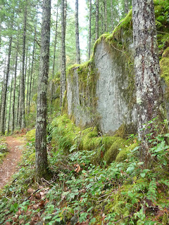
The Boulder Garden trail is now signed again. The sign has been missing for a few years but those who knew about the trail could find it easily enough. The trail starts out on the Little Si trail in North Bend. Find the Boulder Garden trail within 1/8 of a mile or so along the Little Si trail. It’s a pretty trail, especially in the fall with a little bit of fall color still hanging in on the trees and shrubs. Spurs lead to viewpoints from mossy boulders down to North Bend, Rattlesnake Mountain and nearby foothills.

If you’re looking for the Old Si trail it is not signed but when you get to the high point there is another sign for the Boulder Garden trail with arrows pointing both ways. The Old Si trail heads uphill from there. The Old Si trail is steep, in places “rooty” and there are slick spots where wet leaves plaster the trail. We hiked about a half an hour before turning around.

Of course, if you’re doing the Boulder Garden loop continue on the loop (that part of the loop is actually a stretch of the Old Si trail).

We went part way up the Old Si trail but no one in my party felt like going to the top so we turned around and headed back to the Boulder Garden Loop. Rather than complete the loop and return to the car we headed for Little Si.

My companions did not know about the cliffs that are familiar to climbers and scramblers. However, that area is now posted with warning signs to stay on designated trails so if you venture into or onto the boulders/cliffs you have been warned – quite possibly you could get a fine for leaving the trail system. We admired the boulders from a discreet distance as I recalled past scrambles before such signs were posted.

After a look at the off-limits cliffs we retraced our route back to the car via the Little Si trail.

A few days prior I hiked the Talus Loop at Mount Si. The signs were missing for this loop but it’s easy enough to spot. Hopefully the hike is still “legit” because it’s a sweet little hike. I like the trail because it gives me a moderate workout without running into the crowds. Again, I enjoyed the last of the fall color (especially vine maple) and displays of mushrooms all along the seldom-hiked trail. There’s a nifty viewpoint along the trail from a boulder field, the boulder field bordered by vine maples and evergreens.

Kendall Lake Road snowshoe, November 18, 2009


Kendall Lake Road (snowshoe outing), November 18, 2009

Silverback and I caught a break between a seemingly endless series of storms so hurried off to Snoqualmie Pass to beat the next incoming storm. We lucked out – it was still mostly sunny at Snoqualmie Pass and temperatures were comfortable. The ski areas have opened up and late fall is transitioning to winter.

Silverback bought our Sno Park permit and proudly displayed it on the windshield; it had been several years since he had skied or snowshoed. He is still adapting to the Pacific Northwest after living several years in Denver but the Pacific Northwest has been good to him. Since he’s taken up hiking again he’s lost about 70 pounds and a chronic asthma condition has also improved. Nope, he’s not on a drastic diet – just eating healthier food and consistent exercise. Apparently my passion for the mountains is contagious; he gets as restless as I do when we can’t get outdoors.

It had been about 25 years since Silverback had snowshoed; snowshoes have changed a lot since then. I have the popular Atlas snowshoes but Silverback was fine using my old Sherpa snowshoes.

We were a little confused as to where to park at Gold Creek – we knew not to park in the I-90 interchange, of course, but weren’t quite sure where the Gold Creek Sno park began. To be safe from getting towed or getting a ticket (or getting yelled at) we asked a road grader if it was OK to park just shy of the Interchange; he seemed to think that was fine so we left the car there. Someone else had also parked there displaying a Sno Park permit. Whatever you do, don’t park under I-90, you will get towed or a ticket or both.

Back in the late 1980s through the mid-90s I did a lot of cross-country skiing; Kendall Road was one of my favorite trips. However when the skis wore out along with the boots I never replaced them – I’m considering taking it up again but would need to rent equipment and try it out again – I’d be feeling a little “rusty”.

There was a few inches of snow at Gold Creek; enough that we put on the snowshoes right at the start (we knew we’d get into more snow as we gained elevation). Since Silverback was rustier than me when it came to snowshoeing I broke trail and adapted my “forever” pace as I do when I hike.

We were the first on the untrammeled snow and the snow was lovely, the trees festooned with snow, the shrubs bore snow blossoms (fat chunks of snow) and ice crystals glittered in the sun. The forest has grown up enough over the past few years that there is no doubt where to go to continue on the Kendall Lake road. The road starts out on the level but soon veers uphill; you’ll have your work cut out for you.

Since I was feeling frisky I continued to break trail, stopping ever so often to chat with Silverback or take photos. There was no reason to hurry but once I get a rhythm going it’s hard to stop for a long period of time. I was hoping we’d get to the first “viewpoint” where Rampart Ridge comes into view at the end of a switchback but Silverback wasn’t ready for that. That’s OK – he is wise to follow his own “forever” pace.

I waited for him to catch up on the road; then after setting a turnaround time I continued while he stopped for lunch (he said he’d start down after lunch). Ordinarily I am against any party splitting up on winter hikes but the Kendall Road is close to civilization and the weather was fine. After another long switchback I made it to the view of Rampart Ridge; one of my favorite places to take a break whether on skis or snowshoes.

Consulting my watch I still had a few minutes to spare so continued on to the next viewpoint before turning around. I had set my old-fashioned altimeter at the parking lot but it wasn’t functioning properly so I am not 100 percent sure of how much elevation I gained. Hopefully, the altimeter will continue performing as I am fond of that old altimeter and found it reliable. It’s so old it might even be an antique!

I started down and soon met a young woman on skis who had taken the day off to take advantage of the good weather and a little further down the road, another solo skier with his dog. About half way down the road I caught up to Silverback and we snowshoed together back to the car.

The bad weather continued to hold off so we continued our outing by walking the Gold Creek Road to where the road is crossed on a bridge. I can’t count the number of times I’ve driven down that road (or paralleled it on I-90), straining my neck for the brief but gorgeous view of the Gold Creek valley and the peaks at the head of the valley.

Most of the snow that had fallen on the road had melted so it was a simple walk to the bridge. En route we stopped for photographs, drinking in at long last, those views we hungered for.

According to the new-fangled GPS that Silverback carried he’d gained about 750 feet on Kendall Road, estimating I gained about 1,300 feet. Including the road walk his hike ended up being about 5 miles, mine roughly 7 miles.

The rain held off until Seattle – the timing couldn’t have been better.

In addition to snowshoeing, we’ve recently checked out some of the trails near North Bend including Little Si, the Old Si trail, the Boulder Garden Loop and the Talus Loop on Mount Si. I will not describe those hikes in detail here. Anyone who has read this far is probably already familiar with those trails - perhaps even TOO familiar this time of year but watch for updates.


Friday, November 6, 2009

Eagle Peak Saddle, November 4, 2009


Eagle Peak Saddle - November 4, 2009

We felt like we’d got away with something. Pulling off a last-minute high elevation hike without significant snow or foul weather. Last weeks hike to Rampart Ridge was snowy and icy. Today’s hike to Eagle Peak Saddle was like a return to early fall.

To get to the Eagle Peak trailhead park at Longmire, then walk through the parks administration buildings and cross the Nisqually River on a solid bridge. The trailhead can be found just past the bridge on the left-hand side. There’s also a great view of Mount Rainier from the bridge.

The hike starts off in forest with salal, deer ferns and old growth trees; the trail is in good condition though there is one fallen tree to maneuver over or around. At the end of the switchbacks spur trails lead to an un-named tributary that flows into the river. We checked some of these out but the creek is hard to photograph, at least with our digital cameras.

The trail seldom stops climbing until it gets to Eagle Peak Saddle. We set our pace accordingly, what I call my “forever” pace. As we gained elevation the forest became more expansive and it brought back memories of previous visits, including a snowshoe trip on a cold, foggy day a few years ago. I also remembered a summer visit when the meadows below the saddle were a riot of wildflower displays. Mostly, I’ve hiked here alone – it is a good trail for solitude.

The climb is relentless and offers few level stretches to hikers but it’s a small price to pay for the rewards ahead. The forested, secluded trail does not attract many hikers – there are easier trails to get to for views but this trail can be hiked or snowshoed year-round. It’s a good place to go in winter when the road is gated at Longmire and safe as a snowshoe trip, at least for the first 3-1/2 miles.

After crossing the nameless stream on a footbridge the trail levels out for a bit before it resumes its climb. The trees thin out and a rocky peak comes into view above tawny meadows with dabs of fall color here and there. The trail contours below a talus slope then heads uphill again into another forested stretch.

There we ran into a little bit of snow but the snow was soft and didn’t obscure the trail. As the trail emerged from the last stand of trees short, steep switchbacks made quick work of the climb to Eagle Peak Saddle. Here a sign warns hikers they have gone far enough. I almost forgot to mention the views en route to the saddle – once we left the trees we enjoyed views of Mount Adams and Mount Saint Helens, too far away to photograph.

The last stretch of the trail was snow-free; we were glad to get to the saddle without having to negotiate steep snow.

In winter the first 3-1/2 miles of the trail offer a safe snowshoe trip. With snow the summer route becomes hazardous; only experienced hikers with avalanche awareness and winter-travel skills should venture beyond the last forested stretch. Even those experienced in the arts of winter-travel take a different route to get to the saddle, avoiding the open, exposed slopes where danger of avalanche is moderate to high.

As you approach the saddle on the last of the switchbacks Eagle Peak is to the left. There a climber’s path leads to the summit; I tried it once but turned around short of the summit. I was alone and getting to the summit was beyond my comfort level. Besides the view of Mount Rainier and the Tatoosh peaks from the saddle are eye-candy enough for anyone. Bring the map to identify other peaks in the region.

On our way down from the saddle we stopped for another break at the end of the switchbacks for one last view of Mount Adams, Mount Saint Helens and the dark surrounding foothills. As we approached Longmire we spotted a raccoon near the administration buildings, our only “wildlife” sighting of the day.

I bet it’s snowing like Hell up there today.

Rampart Ridge Trail, October 27, 2009


Rampart Ridge Loop (Mount Rainier National Park) October 28, 2009


These hikes at Mount Rainier National Park were only a week apart but as different as night from day. Rampart Ridge felt like a winter hike, Eagle Peak Saddle (to follow) a fall hike.

Hikers who hike year round sometimes refer to late fall/early winter hikes as “snowline probers”. Would we need snowshoes on Rampart Ridge or not? Where was the snowline? The snowline in November rises and falls on a daily basis; no two days in November are alike. Sometimes the only way to find out is to head for the trailhead. We gambled we wouldn’t need snowshoes for Rampart Ridge at Mount Rainier and left them behind.

As it turned out snowshoes were not needed but Yak Trax sure would have come in handy. Fresh snow had fallen but we were not expecting ice.

To find the trail park at Longmire and cross the Nisqually Paradise road to “Trail of the Shadows”, a popular nature trail where this hike begins. We hiked clockwise hoping the gray skies would clear – it’s about a 2-mile climb to the ridge-crest and you’re better off hiking toward Mount Rainier rather than away from it. Turn left and start out on the nature trail. In a few paces you’ll come to a bridge; there was no snow on the bridge but the trail was plastered with fallen leaves, the wooden bridge icy and slick.

The Rampart Ridge trail is well signed and starts on the uphill side of the nature trail. The trail begins to climb immediately at a moderate grade through forest and is in good shape except for icy patches here and there. The iciest patches are along the lower elevations of the trail. Long, lazy switchbacks through the forest lead to an opening in the trees where there is a good view of the Nisqually River.

Signs of fall are just about gone; the oak ferns and bracken are pale, the vanilla leaf thin and mottled, mushrooms have emerged, some of them dusted with snow, others shattered and lying in pieces beside the trail. The huckleberry bushes that hung heavy with fruit not so long ago have lost most of their leaves.

As we climbed fresh snow replaced the ice and at about 4,044 feet we reached a junction where a spur descends to an overlook of Longmire, foothills and the Nisqually River.
After enjoying the view we continued on the main trail to a high point (4,093 feet). The trail is level for a half-mile or so through the forest; here, the snow was 2-3 inches deep.

This is a pretty trail and we delighted in the ice-sheathed branches of shrubs and snow-dusted evergreens, the subdued tones of shrubs and fallen leaves. When we stopped for a break we were immediately surrounded by gray jays (camp-robbers); it is just about impossible not to be delighted with these birds, they are plucky and seem optimistic as they dart about in their endless quest for food. In logging camps they hung around mess-halls, hence camp-robbers. They eat insects, seeds and berries; they are also meat-eaters (better keep an eye on your lunch!).

As the trail levels off there is a good view of Mount Rainier on a clear day but we were denied the view. Given the overcast it was hard to tell the snowy mountain from the white sky. The trail reaches a junction for the Wonderland Trail at 3,912 feet; here we turned right to continue the loop. You’d turn left if you were bound for Indian Henrys Hunting Ground (5 miles further). We turned right again at the next junction where another trail continues to Van Trump Park and Mildred Point.

The Wonderland trail descended toward Longmire; as we descended the snow disappeared and we were on bare dirt for the rest of the hike. We noticed and stopped to admire several grand old-growth conifers on the way. We did slip and slide on a stretch of icy puncheon before coming out on the Nisqually-Paradise road. The trail crosses the road, enters the forest and in less than ¼ of a mile comes out again at Longmire.

We’d had enough of hiking in the cold but weren’t ready to leave Mount Rainier so extended our visit by driving to Christine Falls an attraction we’d driven by many times without stopping (you can see the waterfall from the road). However, to get the best view of the waterfall park on the far side of the stone bridge where a short path descends to a better view of the waterfall, framed by the graceful bridge.

Stats: 4.6 miles round trip, about 1,800 feet of elevation gain.

Thursday, November 5, 2009

Halloween Hike, October 31, 2009


Robe Canyon and Big Four Ice Caves (October 31, 2009)

Sometimes the Monte Cristo Area is at its best when it’s at its worst.

Several of us got together for a Halloween hike in the Monte Cristo area. The setting, of course, was Robe Canyon with its spooky tunnels. With fantasies of getting to the tunnel, lighting candles, eating candy and being generally silly even the downpour could not dampen our spirits.

Besides, the weather report indicated only a 20-30 percent chance of rain. That didn’t sound so bad. As we drove toward the trailhead the rain intensified but we were prepared with rain-gear, good boots and some of us carried umbrellas as well. How hard can it be to hike 3 miles in the rain?

Well, we didn’t get very far - shortly past the point where the trail comes out near the Stillaguamish River we were stopped by a raging ….uh, tributary. Since parts of the trail to that point were literally under water and our feet were still remarkably dry, we thought it best to turn around and enjoy Halloween elsewhere.

My main concern with rain is keeping the camera dry and being able to see through my glasses so I carried and used an umbrella the entire way. My pack got soaked and so did my legs but both pack and legs dried out quickly at home. Despite the deluge we were jazzed by the colors the rain brought out on the trail, the brilliant green of licorice ferns growing on gold-green Big-leaf maples, the gray green of the Stillaguamish River flowing beside the old railroad grade.

Back at the car spirits were still high so Plan B went into effect; we’d celebrate Halloween at the Big Four Picnic Shelter. Diving into the cars, still in our boots, off we went up the Mountain Loop Highway to Big Four. En route we were mesmerized by the “new” waterfalls pouring off the foothills near Lake 22 and elsewhere along the route. Sheets of water, like panes of glass, slid across the highway. It was both ominous and gorgeous.

The Picnic Area was virtually deserted; another party was just leaving so we had the place to ourselves. We gathered under the picnic shelter and ate our lunch, passed out candy and donned our masks. Steve by far had the best costume; he emerged from the restroom in the form of a werewolf. My devil’s horns paled in comparison.

After finishing lunch we hiked out to see the new bridge over the Stillaguamish; we were already wet so we might as well keep hiking. After leaving the picnic area the trail crosses a marshy area on a boardwalk; here the water was almost as high as the boardwalk. It is the kind of rain I have been known to describe as “fat” rain. Big, big drops.

When we got to the bridge we thought we might as well continue to the Ice Caves; why not? Those of us with cameras hunkered down with umbrellas and took photos of mushrooms, the colorful leaves of Canadian dogwood and other vegetation. As the trail rounded a hillside of devastation from floods/blow-outs from recent years ago we came to another “tributary” that was flowing fast and deep enough to call for caution (though by then we were so wet it wouldn’t have mattered if we’d stepped into the water).

After leaving the mangled forest we came to another series of boardwalk and bridges; here it had rained so hard that the boardwalk was covered with water in places. One bridge is broken in the middle with a wicked slant; you can bypass it by walking beside it.

We were surprised by the fall color that still surrounded the ice caves and the waterfalls spilling down the cliffs of Big Four; the bad weather seemed to only enhance the rugged beauty.

Though the elements were downright unfriendly we felt it was a privilege to spend time there – however, we gratefully stopped in at Ike’s at Granite Falls for hot drinks and food before driving home.