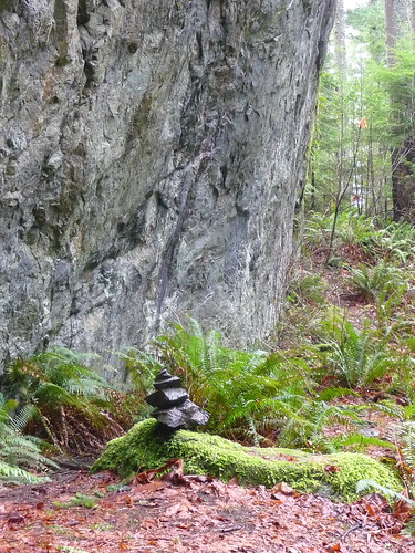
Here is a photo of the Boulder Garden Trail, the approach to the Old Mount Si Trail. The snow is much higher on the mountain but the Boulder Garden Trail is beautiful in a different way.
Thursday, February 28, 2013
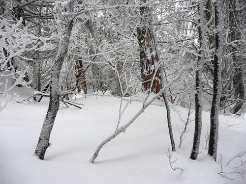
Winter lace, Old Si Trail
Here, finally, is a photograph of our recent hike to Mount Si via the Old Big Si Trail
Old Big Si Trail, February 27, 2013
Mount Si via the Old Mount Si Trail (North Bend, Washington)
Maybe you need to be just a little bit nuts to hike up the Old Mount Si trail in wind, rain and snow. Or maybe you’re just trying to stay (or get) into shape. However, it’s not often you’ll find Mount Si as lonesome as it was Wednesday, February 27.
Whatever your motivation, whether its for exercise or solitude, winter is a great time to hike up this oft-crowded trail where you stretch your facial muscles saying “Howdy” to other hikers coming or going more than your legs. No matter which trail you take to the base of Mount Si, it’s about an 9-mile hike with 3,300 feet of elevation gain.
We parked at the Little Si trailhead, opting for the Old Si trail via the Boulder Garden Loop trail as that is a more scenic approach. We weren’t sure how far we’d get given marginal weather and more rain in the forecast so we started out agreeing to turn around when either of us were ready to do so. We’d both gone on runs the previous day so weren’t sure what kind of shape we’d find ourselves in so paced ourselves accordingly with a measured but steady pace.
The hike begins with a short, steep pitch directly from the parking lot – take advantage of a couple of thank-heavens views from mossy outcroppings of the upper Snoqualmie Valley and on a clear day, Rattlesnake Ledge. After that abrupt huff-and-puff the trail levels out for a bit to the east end of the Boulder Loop Trail (it is signed) where we turned right, uphill. This is a slightly gentler climb than from the west trailhead and scenic with mossy cottonwoods, sparkling-with-rain lichen festooned branches of shrubs on an old road turned trail.
You’ll pass moss-slathered cliffs, boulders and side-trails to mossy overlooks (try to avoid walking on the moss and keep in mind the rocks are slick on a wet day). For a challenge take the map/compass/GPS and see if you can find Foundation Rock before you turn off onto the (presently unsigned) trail hikers know as the Old Si Trail. Though it is not an official route you’ll recognize this site as climbers occasionally practice on the cliffs below (we spotted hardware). Watch turns, unsigned junctions and side-trails of which there are many.
You will need to watch for the turn (uphill, right) where the Old Mount Si Trail begins (as of this writing the trail was not signed). Find it about it at about 800 feet elevation the start of the Boulder Loop Trail.
Once on the Old Si Trail you’ll notice the steepness of the grade; pace yourself, it seldom relents. On a hot summer day with high humidity you might opt to give up hiking; we prefer hiking Si by either route in the fall, winter and spring.
The trail is easy to follow with a few, slippery stretches over rocks slimed with mud or wet vegetation. After one particularly steep stretch the trail relents a bit as it continues with well-defined switchbacks with a more reasonable pitch. There is even a short, level stretch on an old road before the trail spurts insanely upward again with shorter and steeper switchbacks.
Not far from the old road we began to hit short stretches of snow and mud. We’d brought traction devices with us so we were prepared. Indeed, we met one climber coming down who said he’d made it to Haystack Basin but that he had used traction devices further up the trail and also mentioned there were good steps to follow in the deeper snow above. We soon stopped to put on our traction devices for conditions we’d be facing.
Once we got to the unsigned junction where the Old Si Trail provides a link to the Mount Si trail the snow deepened quickly, almost enough to warrant snowshoes. This old stretch of the Old Si Trail is short and steep but it’s also one of the prettier sections, especially with trees and shrubs festooned with fresh snow, like walking into a Christmas card.
With an eye on time (you should keep an eye on time too!) we agreed to continue to at least the set of rocky steps below Haystack Basin. Given the conditions I stopped a little shy of the snow-encrusted rocks, my companion carried on a little further for a better view of Mount Si though it was late and cold enough she didn’t linger. Though she is agile and prepared for such conditions I watched her descend the rocky steps with my heart in my throat since we appeared to be the last people up there.
We made a quick descent; it took us about two hours from the rocky outcroppings to the Little Si trailhead. En route we’d only met one couple on the Boulder Garden Loop and there was only one other car at the trailhead. Though we’d scampered down quickly it was challenging to keep scampering; not because we were tired but because the scenery was so beautiful (there was not enough time for photography).
By the time reached North Bend the heavy rain arrived with darkness on its heels.
Getting there: To get there: From Seattle head east on I-90 and get off I-90 at Exit No. 32 signed 436th Avenue SE. Go left (over the interstate) and continue ½ mile to North Bend Way and turn left. Continue about ¼ of a mile (toward North Bend) and turn right onto Mount Si Road. Continue to the designated trailhead/parking lot (left) shortly after crossing the Middle Fork Snoqualmie River. A Discovery Pass is required for the Little Si Trailhead and the Mount Si trailhead.
Additional Information: Map Green Trails No. 206S (Side A) Mount Si Natural Resources Conservation Area (NRCA). The land management agency is DNR (Washington Department of Natural Resources). On my Green Trails map (2002) the trail is called the Old Big Si Trail. The hike is about 9 miles round trip (including mileages on the Little Si Trail/Boulder Garden Trail). An interesting read about Mount Si is the out-of-print “Guide to Mount Si” by Robert E. DeGraw. Though some of the trail numbers/road numbers may be out of date this book is the most-researched guide to Mount Si I’ve ever had the privilege to read and dream. For current trail/road conditions the most up-to-date resource is Washington Trails Association www.wta.org .
Karen Sykes
Subscribe to:
Posts (Atom)
