Thursday, May 2, 2013
Ebey's Landing Preserve National Historic Preserve, April 26, 2013
EBEY’S LANDING PRESERVE NATIONAL HISTORICAL PRESERVE (Whidbey Island)
Mention “Ebey’s” and hikers ears perk up; it is a year-round favorite. Hike as little or as far as you wish, clockwise or counterclockwise, view Perego’s Lagoon from the bluffs or the shore, (consult a tide-table before hiking the beach). Dawdle; daydream, watch ships come and go where water seemingly meets sky. Enjoy a Rip Van Winkle nap in a sheltered spot out of the salty breeze.
The scenery alone will sate your appetite for beauty but there’s more – there are interpretive signs featuring early explorations of the region and the Native Americans who lived on Ebey’s Prairie before settlers arrived. You can also hike from the bluffs to Sunnyside Cemetery, a pioneer burial ground, one of the most beautiful, poignant cemeteries we’ve ever visited.
Ebey’s Landing is not only protected by the rain shadow of the Olympic Mountain range it is also protected by land-management agencies including The Nature Conservancy, the United States Department of Fish and Wildlife, Washington State Parks. The reserve is also home to rare plants including golden paintbrush, a rare Indian paintbrush known to exist in only a few places. Be on the watch for gray whales, eagles and a variety of seabirds including harlequin ducks near Parego’s Lagoon.
We suggest hiking a 3.5-mile loop (our favorite) starting at the bluffs with views of Perego’s Lagoon, the Olympic Peninsula, the Straight of Juan de Fuca, even Mount Rainier on a clear day. The trail skirts the edge of lowland forest as it parallels the beach. From the bluff trail you can also enjoy a short, easy walk to the Sunnyside Cemetery (the junction is signed). Unless tides prohibit, don’t miss out on the beach-walk.
On our recent visit we noted that a couple of our favorite, wind-gnarled Douglas firs along the bluffs had fallen - no surprise given that such bluffs are prone to erosion in a silent, endless war between land and water. Past the lagoon you’ll come to a steep, obvious trail that drops down to the beach. Over the years feet have beaten shortcuts down to the beach; stay on the main trail - not only is it safer, it is gentler on the terrain.
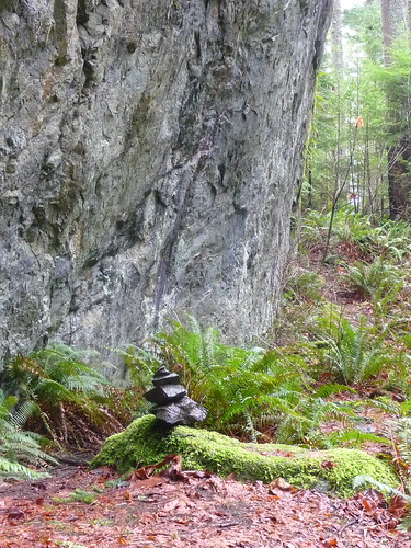
There are several ways to hike the beach; if you’re agile you can dance along the driftwood, otherwise along the beach when tides are low or a trail that skirts the lagoon. Notice the different shapes of driftwood - let your imagination go and conjure fearsome or magical shapes cast up by the sea. Root-balls have floated from afar and come to rest at the edge of the lagoon – hikers often decorate these root monsters with stones and pretty shells.
On cloudy, rainy days it is often hard to tell where fog ends and water begins – in such conditions your other senses sharpen and you’ll hear the mournful wail of foghorns and the colors of rocks and seaweed will jump out at you in psychedelic shades. Don’t overlook the colorful views at your feet.
Though it was a spring day we didn’t see many wildflowers along the bluffs; however, the beach was another story presenting a kaleidoscope of seaweed, driftwood, kelp, pebbles and stones of every shape, size and color imaginable. We marveled at their intricate markings, some so smooth they felt polished others rough conglomerates glinting with minerals and agate striations. Other rocks were black as obsidian with a white blaze running through them like a bolt of lightning, no two alike. In contrast yellow coils of kelp glistened on the damp sand like ropes, knotted and twisted by eternal moon-pulled tides.
Since Time was fleeting we drove to the Sunnyside cemetery rather than hike the trail. Sunnyside is a pioneer cemetery dating back to the mid-1800s. Native American tribes lived on the prairie for thousands of years and established the burial ground. According to their custom, they usually interred their dead by burying them in chests or canoes up in trees but that custom was abandoned within a decade after white settlers arrived.
Headstones date back to the 1850s, including that of Isaac Ebey, an early settler. Ebey chose the prairie as a homestead for its beautiful setting overlooking Admiralty Inlet and the Olympic Mountains. During the Indian Wars of the 1850s, Ebey was killed by Haida Indians in retaliation for an ambush of their people by whites. The Haidas needed to kill a “white chief” to avenge their loss of one of their chiefs. The historic Davis Blockhouse can also be found at Sunnyside; one of many such structures built as a refuge in the event of attack.
Getting there from Mukilteo-Clinton ferry: take Highway 525 north -- it eventually becomes State Route 20. Continue through Coupeville on State Route 20 and take the first left after the pedestrian overpass onto Ebey Road. Continue straight – do not take the curve to the left. Go straight toward the water and as you approach the water the road descends right to trailhead parking and restroom. A Discover Pass is required.
To drive around from Seattle: go north on I-5 to Exit No. 230 (State Route 20), past Mount Vernon. Get off there, turn left at the stoplight and continue on SR 20 for about 15 miles. Near Anacortes turn left at the sign for “Oak Harbor, Whidbey Island, Deception Pass” and continue on SR 20 (about 20 miles). As you approach Coupeville turn right on Ebey Road – if you get to the overpass you’ve gone a bit too far.
Trail data: Ebeys Landing Loop, 3.5 miles, about 200 feet gain.
Additional information: For additional information visit the website for Washington State Parks at www.parks.wa.gov/ .
For additional human and natural history of the region here’s some interesting websites: The Nature Conservancy at http://nature.org/wherewework/northamerica/states/washington/preserves , the National Park Service at www.nps.gov/ebla/ , or Sunnyside Cemetery at www.sunnysidecemetary.org/ .
Karen Sykes
Thursday, April 4, 2013
Photographs to accompany Hike of the Week, Oyster Dome
Here is a link to my photographs of Oyster Dome - for unknown reasons I am not able to download photos onto this website. I think it is probably a lack of intelligence on my part, though. Meanwhile, here is the link. After getting onto Flickr click on the first set of photographs entitled "Hike of the Week".
Here is the link: http://www.flickr.com/photos/karenseyes/
Oyster Dome, Chuckanut Mountains, March 2013
OYSTER DOME (Chuckanut Mountains)
If I could count the number of times we’ve hiked to Oyster Dome in the Chuckanut Mountains it would be in the double digits. Though we especially relish hiking trails we haven’t hiked before this trail is an exception to my rule. There are reasons for frequent visits: you can hike the trail year-round, snow is seldom a concern and the views from Oyster Dome are terrific.
However, those in search of solitude might want to avoid the trail on a warm, sunny weekend or be prepared to share the sunny outcroppings with other hikers. On our recent visit we shared the sunny overlook with a cheerful family, including a 10 year old boy who still had enough energy to climb a nearby tree and perform acrobatics on the branches. As for us, we were ready for a rest!
If that’s not enough to whet your appetite for year-round scenery you can include a visit to the Tulip Festival at Roozengaarde in Skagit County (open April 1-April 30). On a sunny day there are not only daffodils and tulips to admire, there are also stunning views of Mount Baker.
The hike to Oyster Dome is about 5.7 miles round trip with an elevation gain of 1,800 feet. If you don’t want to work that hard you can instead hike up to Samish Overlook from the same trailhead – that’s only 4 miles round trip with 1,100 feet gain. At Samish Overlook you’ll enjoy views of Samish Bay and the Olympics on a clear day (bring a map to identify the islands). When there’s a stiff breeze this is also a take-off point for paragliders. Once aloft they look like giant butterflies in the sky.
The trailhead is off Chuckanut Drive (State Route 11) with parking along the road. The hike begins on the Pacific Northwest Trail (PNT) with a large rock marker displaying the PNT mileages between the Rocky Mountains and the Pacific Coast.
The trail starts off climbing in long switchbacks to a couple viewpoints of Samish Bay (one with a bench) before meeting the signed junction for Samish Overlook and Oyster Dome. Go right (uphill) to Samish Overlook or continue straight to Oyster Dome.
Though it was a little too early for wildflowers the flowering shrubs were beginning to unfurl their leaves and it was a pleasure to hike through this heady mix of evergreens, deciduous trees, shrubs and ferns in dappled light.
After gaining most of the elevation we negotiated a couple of minor creek crossings and muddy areas where balancing on rocks and slick roots required some agility and just plain luck. Hence we advise sturdy hiking boots; in spring consider gaiters as well. There are also a couple of steep stretches that require a bit of maneuvering but nothing that could be considered dangerous.
As the trail gradually ascends toward Oyster Dome you’ll pass large outcroppings interspersed through the forest and a small sign for the Ice Age Trail (left). Hikers familiar with the trail system sometimes descend a short distance to the boulder field known by some as the bat caves; do not enter the caves as they provide a habitation for bats. Plus, these are not actual caves but rather a large jumble of boulders. In short, it’s a good place to twist your ankle so exercise care.
Most trail junctions to Oyster Dome are signed though not far from Oyster Dome you’ll encounter an unsigned junction; here, stay left, head uphill. From there the main trail is easy to follow (you will also be encountering other hikers) though there are socially engineered side-paths that run hither and yon; none lead to better views.
After a short, steep climb the main trail opens out onto a long, broad rock outcropping with what could only be described as “sudden” views, the kind of views that make a first-time visitor exclaim “WOW!” Oyster Dome sits above the boulder field with plenty of sitting room, even on a busy day. Here enjoy unobstructed views of Samish Bay, the Olympics and an array of scattered islands. Keep away from the edge of the outcropping and keep track of your children and/or dogs.
Additional Information: The hike to Oyster Dome and Samish Overlook is 7.7 miles round trip with 2,300 feet gain. Samish Overlook by itself is 4 miles round trip with 1,100 feet gain. Oyster Dome by itself is about 5.7 miles round trip with roughly 1,800 feet gain.
Driving directions: From Seattle head north on I-5 and get off at exit 231 signed Chuckanut Drive, State Route 11. After negotiating two roundabouts continue west about 18 miles to the trailhead. Parking is limited to the left hand shoulder (don’t park where signs prohibit such). For additional information on visiting Roozengaarde visit their website: www.Tulips.com
Karen Sykes
Thursday, February 28, 2013
View, Boulder Garden Trail
Here is a photo of the Boulder Garden Trail, the approach to the Old Mount Si Trail. The snow is much higher on the mountain but the Boulder Garden Trail is beautiful in a different way.
Winter lace, Old Si Trail
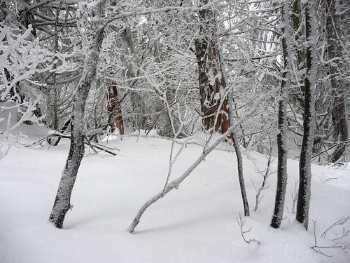
Here, finally, is a photograph of our recent hike to Mount Si via the Old Big Si Trail
Old Big Si Trail, February 27, 2013
Mount Si via the Old Mount Si Trail (North Bend, Washington)
Maybe you need to be just a little bit nuts to hike up the Old Mount Si trail in wind, rain and snow. Or maybe you’re just trying to stay (or get) into shape. However, it’s not often you’ll find Mount Si as lonesome as it was Wednesday, February 27.
Whatever your motivation, whether its for exercise or solitude, winter is a great time to hike up this oft-crowded trail where you stretch your facial muscles saying “Howdy” to other hikers coming or going more than your legs. No matter which trail you take to the base of Mount Si, it’s about an 9-mile hike with 3,300 feet of elevation gain.
We parked at the Little Si trailhead, opting for the Old Si trail via the Boulder Garden Loop trail as that is a more scenic approach. We weren’t sure how far we’d get given marginal weather and more rain in the forecast so we started out agreeing to turn around when either of us were ready to do so. We’d both gone on runs the previous day so weren’t sure what kind of shape we’d find ourselves in so paced ourselves accordingly with a measured but steady pace.
The hike begins with a short, steep pitch directly from the parking lot – take advantage of a couple of thank-heavens views from mossy outcroppings of the upper Snoqualmie Valley and on a clear day, Rattlesnake Ledge. After that abrupt huff-and-puff the trail levels out for a bit to the east end of the Boulder Loop Trail (it is signed) where we turned right, uphill. This is a slightly gentler climb than from the west trailhead and scenic with mossy cottonwoods, sparkling-with-rain lichen festooned branches of shrubs on an old road turned trail.
You’ll pass moss-slathered cliffs, boulders and side-trails to mossy overlooks (try to avoid walking on the moss and keep in mind the rocks are slick on a wet day). For a challenge take the map/compass/GPS and see if you can find Foundation Rock before you turn off onto the (presently unsigned) trail hikers know as the Old Si Trail. Though it is not an official route you’ll recognize this site as climbers occasionally practice on the cliffs below (we spotted hardware). Watch turns, unsigned junctions and side-trails of which there are many.
You will need to watch for the turn (uphill, right) where the Old Mount Si Trail begins (as of this writing the trail was not signed). Find it about it at about 800 feet elevation the start of the Boulder Loop Trail.
Once on the Old Si Trail you’ll notice the steepness of the grade; pace yourself, it seldom relents. On a hot summer day with high humidity you might opt to give up hiking; we prefer hiking Si by either route in the fall, winter and spring.
The trail is easy to follow with a few, slippery stretches over rocks slimed with mud or wet vegetation. After one particularly steep stretch the trail relents a bit as it continues with well-defined switchbacks with a more reasonable pitch. There is even a short, level stretch on an old road before the trail spurts insanely upward again with shorter and steeper switchbacks.
Not far from the old road we began to hit short stretches of snow and mud. We’d brought traction devices with us so we were prepared. Indeed, we met one climber coming down who said he’d made it to Haystack Basin but that he had used traction devices further up the trail and also mentioned there were good steps to follow in the deeper snow above. We soon stopped to put on our traction devices for conditions we’d be facing.
Once we got to the unsigned junction where the Old Si Trail provides a link to the Mount Si trail the snow deepened quickly, almost enough to warrant snowshoes. This old stretch of the Old Si Trail is short and steep but it’s also one of the prettier sections, especially with trees and shrubs festooned with fresh snow, like walking into a Christmas card.
With an eye on time (you should keep an eye on time too!) we agreed to continue to at least the set of rocky steps below Haystack Basin. Given the conditions I stopped a little shy of the snow-encrusted rocks, my companion carried on a little further for a better view of Mount Si though it was late and cold enough she didn’t linger. Though she is agile and prepared for such conditions I watched her descend the rocky steps with my heart in my throat since we appeared to be the last people up there.
We made a quick descent; it took us about two hours from the rocky outcroppings to the Little Si trailhead. En route we’d only met one couple on the Boulder Garden Loop and there was only one other car at the trailhead. Though we’d scampered down quickly it was challenging to keep scampering; not because we were tired but because the scenery was so beautiful (there was not enough time for photography).
By the time reached North Bend the heavy rain arrived with darkness on its heels.
Getting there: To get there: From Seattle head east on I-90 and get off I-90 at Exit No. 32 signed 436th Avenue SE. Go left (over the interstate) and continue ½ mile to North Bend Way and turn left. Continue about ¼ of a mile (toward North Bend) and turn right onto Mount Si Road. Continue to the designated trailhead/parking lot (left) shortly after crossing the Middle Fork Snoqualmie River. A Discovery Pass is required for the Little Si Trailhead and the Mount Si trailhead.
Additional Information: Map Green Trails No. 206S (Side A) Mount Si Natural Resources Conservation Area (NRCA). The land management agency is DNR (Washington Department of Natural Resources). On my Green Trails map (2002) the trail is called the Old Big Si Trail. The hike is about 9 miles round trip (including mileages on the Little Si Trail/Boulder Garden Trail). An interesting read about Mount Si is the out-of-print “Guide to Mount Si” by Robert E. DeGraw. Though some of the trail numbers/road numbers may be out of date this book is the most-researched guide to Mount Si I’ve ever had the privilege to read and dream. For current trail/road conditions the most up-to-date resource is Washington Trails Association www.wta.org .
Karen Sykes
Subscribe to:
Posts (Atom)
