SCOTTISH LAKES HIGH CAMP (September 22-23, 2011)
You may have second thoughts about a visit to Scottish Lakes High Camp when a rusty, wind-shield cracked vehicle (or snowmobile) meets you at the gated road where the fun begins. Relax, the rollicking ride on this four-mile, rock-studded, pot-holed road is a jolly prelude to good times. Let the romp to the cabins or the Day Lodge be part of the experience. The proprietors, Don and Chris Hanson, wear many different hats and they are veterans of transporting guests up and down the road. When it snows, the aging Suburbans are replaced by Snowmobiles and Sno-cats and having experienced the ride to High Camp in winter we can attest you are in good hands. Don and Chris keep the high camp in top-notch conditions and their loyal care-takers when they are not available are the best. Zeke, the caretaker we met, was as likable as the Hansons and was patient with us when we had trouble getting a fire started in the cabin designated for our stay.
Not only are the Hansons and caretakers able to handle just about any contingency, they are patient with their patrons (I left my sleeping bag on the front porch in Seattle along with a couple other items). I’d like to blame such forgetfulness on anticipation rather than age though I’m probably not the first to leave a sleeping bag nor will I be the last.
Rest assured you won’t freeze to death if you forget your sleeping bag or have trouble lighting the fire (I was able to borrow a sleeping bag). If that’s not enough to attract you to spend at least one night at this remarkable place the Day Lodge is open from 8 a.m. to 8 p.m. Coffee is free though Zeke cautioned that if you want coffee before 8 a.m. it’s $5 a cup. We think he was joking.
The day lodge also provides maps (some created by the Hansons), reading material, games, puzzles and other amenities including a sauna and hot tub where you can relax and ponder the stars in the night sky.
Since it was mid-week we were the only guests (weekends are busy!) and our cabin, Larkspur, was ready for our arrival. After the rollicking ride the Hansons delivered us, with our gear, cooler and food, to the front door of Larkspur Cabin, a delightful A-frame cabin with a front porch and a loft.
Other than bringing your own food (and a sleeping bag!) just about everything else is provided other than hiking gear, skis or snowshoes. There were instructions inside the A-frame as how to light the propane lamps, light the fire in the woodstove and other helpful instructions on how to live off the grid for a while.
We were eager to hit the trails; it was a sunny day and fall color was beginning to show in the mountains. With a Green Trails map (Chiwaukum Creek) and a map of trails created by the Hansens of their trail system leading to McCue Ridge and other points of interest we set out for Chiwaukum Lake (6 miles round-trip) and Larch Lake (10 miles round trip). We started from High Camp and followed the trail system as it climbed through forest and tawny meadows toward McCue Ridge.
With plenty of time at our disposal we stopped to admire the wildflowers; many had faded though the buckwheat was still colorful and the desiccated leaves of balsamroot made for natural dried flower arrangements tethered to the mountain. Where the trail was vague there were cairns to follow as the trail continued to climb.
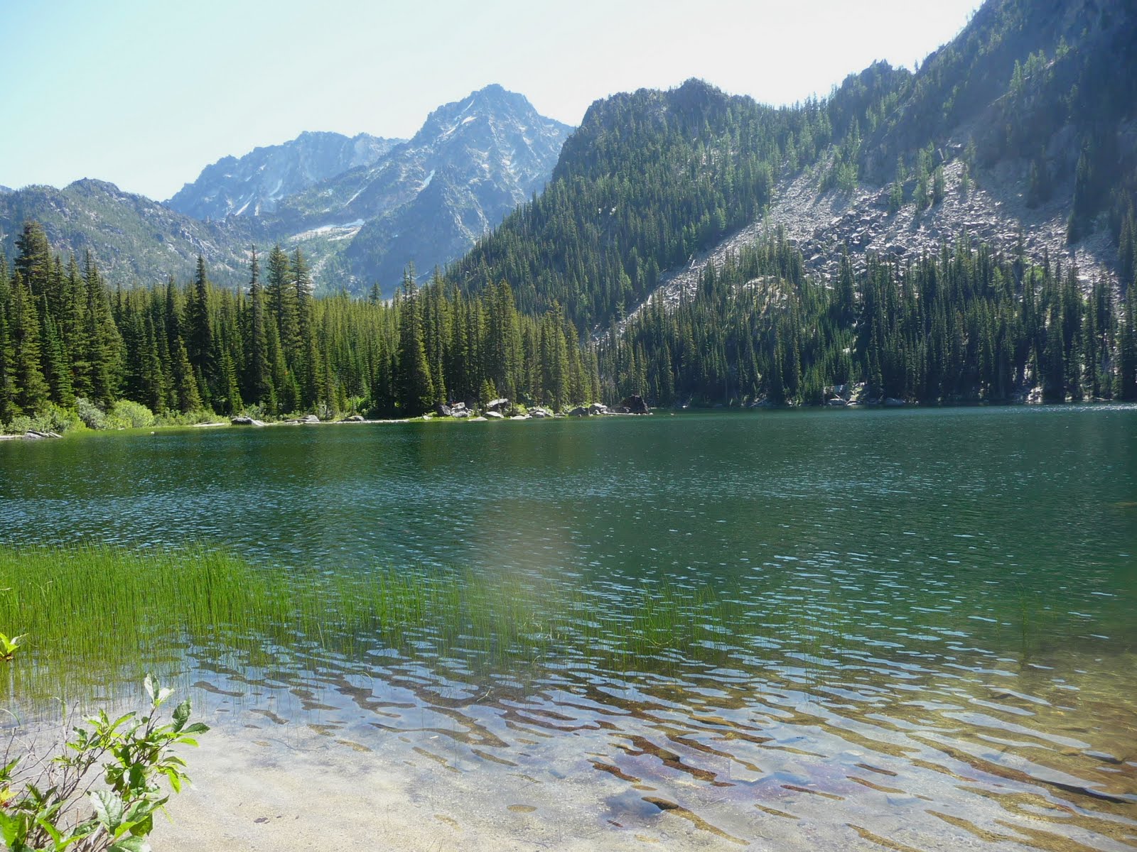
At an unsigned junction on McCue Ridge we turned left. If Lake Julius is your destination go straight. Just before the trail begins its descent to Chiwaukum Lake there are glimpses of the mile-long lake through the trees, then it disappears again. As the trail loses elevation it skirts hanging meadows just beginning to pick up fall colors, especially the fireweed, a brilliant red. The trail returns to forest and remains there, dropping more steeply until it breaks out at the far end of the lake, elevation 5,250 feet.
Though we didn’t see a trail sign we knew to turn right for Larch Lake. First we walked a short spur that led to a perfect spot for lunch in a clearing with logs to sit on at the edge of the lake. Here dark sedges and billowing green reeds bordered the lake and it was so peaceful there that my companion elected to wait there as I continued to Larch Lake.
To ensure we had plenty of time to hike out so we established a time to rendezvous at Chiwaukum Lake. That gave me an hour to get to/from Larch Lake but since that left no time for photography I opted to spend time in Ewing Basin which is situated between the lakes.
If Larch Lake (or Ewing Basin) is your goal - from Chiwaukum Lake the trail continues two miles to Larch Lake, skirting a large meadow on the way and crossing Chiwaukum Creek (an easy hop, skip and jump). After crossing the creek the trail began to open up as it entered the basin so I slowed my pace accordingly.
Ewing Basin is a about a mile from Chiwaukum Lake, a sublime high-country setting with touches of fall color in a boulder-strewn meadow, blueberry shrubs touched with crimson, ridges stretching above with hanging meadows, some still green, others just turning russet. As if that were not enough to keep a hiker spellbound there were still wildflowers in bloom including Indian Paintbrush, arnica, yarrow and blue gentians, a late-summer flower that heralds the end of summer.
It was so beautiful in Ewing Basin that I felt almost guilty for having the whole basin to myself. I knew I would never be able to find the words to describe such beauty so I focused on photography, hoping that my photographs could compensate for the inadequacy of words.
Muttering to myself about the tyranny of the clock and shorter days, I headed back, always mindful about sticking to a turnaround time when someone is waiting. Larch Lake would have to wait for another day. It was little solace that I’d been to Larch Lake so long ago that digital cameras hadn’t even been invented. What remains of that long-ago visit is a box of slides in the basement and good memories. Chiwaukum Lake is beautiful but plan on getting to Larch Lake if you can for even wilder and scenic views.
Back at Chiwaukum Lake my companion was waiting for me (I was only one minute late!) and we trudged out of Chiwaukum Lake already anticipating the comforts of the cabin. Hikes always take longer going out it seems – fortunately there were scenic spots the entire way back, including the way the late afternoon light brushed the dark ridges and mountains with a copper tinge.
The next morning we took an easy walk to Picnic Point (about two miles round trip from High Camp). The walk is on a gravel road through clear cuts with views of Glacier Peak. The clear cuts provide a feel for the topography; you can see the spine of the mountains rising from the earth and vegetation beginning to fill in the blank spots that were logged. First we stopped at the short spur to Glacier View (well signed) in hopes of getting a view of Glacier Peak but the clouds were too low. Glacier View is about half-way to Picnic Point where the road ends at an old landing with a connection to the McCue Ridge Trail. A picnic table is provided, of course, where you can enjoy a snack or feast on the views.
Additional Information: You can also approach Chiwaukum Lake and Larch Lake from the Chiwaukum Creek trail though that is a much longer approach and best done as a backpack. The map is Green Trails No. 177 (Chiwaukum Mountains). Other hikes easily within reach of High Camp are Lake Julius and Loch Eileen. Call the Wenatchee River Ranger District in Leavenworth for additional rules/regulations at 509-548-6977 or visit their website at www.fs.fed.us/r6/wenatchee
For additional information on lodging, rates and seasonal bests or to make a reservation at Scottish Lakes High Camp call 509-763-3044 or visit the website: http://www.scottishlakes.com . You can also view the site for winter cabin availability (2011-2012), a trail map (including ski trails), and a 5-day weather forecast. Dogs are OK if well-behaved and last but certainly not least, Scottish High Camps is also family friendly.
Karen Sykes